
Eastern Queensland (2014) Diary

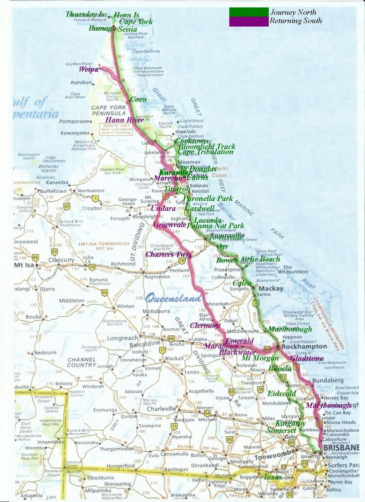
Friday, 4th April, to Monday 7th April
Texas in the Southern Downs region (Qld) on the NSW border. A fantastic weekend for Joy to catch up with her long-term friend, Ann and celebrate Ross' 60th. The Queensland countryside, all the way from Brisbane to Texas was a picture of green pasture due to the recent good rains through central and eastern Qld.
We stayed at Ann/Ross' property - Rose Valley, and while we were there visited Inglewood, Texas and some of the nearby attractions and museums.
14-4-2014
Monday
We left for our 3-4 month Qld trip this morning, dropping in on Dave's Mum for a
cuppa and then drove 120kms west and then north to Lake Somerset
and Lake Somerset Holiday Park in the region of Kilcoy(Q) for 4
nights. After booking in at the park we drove to our site and took our 2 grey
chairs out of the boat before putting the boat in the water. When we returned,
the chairs were gone! and we thought 'Gee that didn't take long before someone
stole them!' I thought to myself that maybe the caretaker, driving around in his
little golfcart, may have thought they were left behind from the previous site
occupant and removed them. I went to the office and found out that that was
exactly what happened. The next morning the caretaker dropped them back to us
early, and he told us he had to fish them out of the big rubbish bins early
before the garbage truck came, because that's where he threw them! He said
people leave all sorts of things behind that they don't want and he has to toss
them.
After setting up we walked to the boat and drove out to put our red claw pots in
the water. It was overcast and still a bit rainy. Can't remember if I mentioned
last year when we were here - but the dam is full of tree skeletons, something
out of a scary movie. These bare, lifeless, eerie-looking trees in various
stages of decay, are what's left after the dam was built and the land flooded,
producing Somerset Dam. No wonder they don't allow boating on the dam after 6pm.
15-4-2014 Tuesday
Lovely and sunny this morning. Dave checked the pots early and only got 5 very
small red claw out of 8 pots! so he moved their location. Checked again this
afternoon and nothing! Lucky it's the start of our trip and we have a fridge
full of food.
16-4-2014 Wednesday
Another beautiful sunny day. Dave went to check the pots early this morning but
ran out of petrol before he got too far, and had to paddle the boat back to
shore in a zig zag fashion, which took about an hour! He was a bit worn out when
he got back. After a big rest he made a couple trips on the scooter to the town
of Kilcoy, for a couple cans of fuel. We then checked the pots and finally got
some decent sized red claw (but only about 5). We still have to be frugal with
the fuel though, until we fill up at the next garage. Other than that we had a
relaxing day.
17-4-2014 Thursday
Dave checked the pots early again today and got about 20 red claw. He pulled all
the pots out though due to the fuel shortage and we're leaving the park in the
morning. The place really started filling up today, with all the campers for
Easter. It is surprising how quiet it actually is here tonight considering how
many people and kids are here.
18-4-2014 Friday Good Friday
We said bye to Lake Somerset this morning and drove 121kms west and then north
to the town of Kingaroy(Q) and the Kingaroy Showgrounds Caravan Park
for 2 nights. We gratefully left the crowded Somerset Dam park this morning,
after getting the boat out of the water. We were spoilt for places to park at
the showgrounds with lots of room, and it is so nice and quiet. On the way we
stopped at Kilcoy and walked through the small markets and bought some local
fruit and veg.
19-4-2014 Saturday
We rode the scooter into the main centre of Kingaroy this morning, to the
tourism office. Right next door, nestled under the shadow of the National
Heritage listed large white Peanut Silos which holds about 13,000 tonnes
of peanuts, is the Kingaroy Heritage Museum. The museum is housed in the
former Kingaroy Power House (1925-1952)
and showcases the history of the Kingaroy region under the themes "People,
Power and Peanuts". There were many and varied displays, including the
peanut growing stages, a variety of peanut harvesting equipment (many locally
designed) , timber industry, pioneers and some phone and switchboard equipment.
Of course, Kingaroy is mainly known for its peanut growng although these days
diversification with other crops has helped when yields haven't been their best,
and peanuts arrive here for processing from several areas in Qld, as well as NSW
and the Northern Territory. Peanut products are also shipped overseas. One of
the men at the museum took us outside to show us a garden where peanut plants
have been grown specifically to show customers. A beautiful large Bicentennial
Quilt hangs near the front door, designed to reflect the history of the
district and presented to the people of Kingaroy on Australia Day 1988.
After leaving the museum we had lunch at the Corrallee Hotel and then walked
down the road to Carroll Cottage which was Kingaroy's first house built
in 1901. It was a small lowset wooden house but no viewing inside. Next we rode
up to Apex Park Lookout which showed views over the town, the Peanut
Silos to the Bunya Mountains. We stopped at the Peanut Van on the way
home to taste and buy some of the many flavoured peanuts.
Some interesting facts:-
- Kingaroy was named after the aboriginal word "Kingarooi" meaning the
red ant, native to the district.
- Peanuts are not nuts at all - but legumes related to beans and lentils.
- Astronaut Allen Sheppard took a peanut with him to the moon.
- The original peanut silos burnt down in 1951.
20-4-2014 Sunday Easter Sunday
Leaving the caravan park this morning we drove 224kms north and then west to the
town of Eidsvold(Q) and Eidsvold Caravan Park for 2 nights. It's a
small but lovely, neat, quiet little park just a short walk out of town. About
half way here we stopped at the town of Ban Ban Springs, although there only
seems to be a garage and across the road, a designated overnight rest stop for travelers,
beside the springs. The springs were an important watering place for the bullock
teams many years ago and now support birdlife and many surrounding trees. The
area is a sacred site for the Aboriginal people. It would've been a lovely place
to stop overnight.
21-4-2014
Monday Easter Monday
This morning we walked across the golf course at the back of the caravan park,
to the RM Williams Australian Bush Learning Centre - a centre dedicated
to preserving and cultivating the area's unique bush culture. RM Williams whose
name would become synonymous with the quintessential Aussie boots, was born in
Belalie South Australia but half a century and countless miles and experiences
later, called Eidsvold home. His beloved 'Rockybar' property had literally been
hacked out of the bush by hand many years before, and his bond with the place
ran so deep that he wrote of its almost mystical qualities in the years that
followed. The learning centre is dedicated to preserving and cultivating the
area's unique bush culture by conducting training workshops in bush crafts,
leatherwork, blacksmithing, arts and crafts. It also hosts meetings and
conferences, and hosts outdoor activities including working dog schools, Bush
Spirit Festival and Rural Industry events. RM had a profound respect for the
Aboriginal people with whom he lived and worked during his life, and local
Aboriginal culture is an integral part of the Centre's essence.
We walked back to the small town for a lovely pub lunch before taking the short
walk back to the park.
22-4-2014 Tuesday
After leaving the caravan park this morning we did a small shop at the local
supermarket and then drove 269kms north to the town of Mount Morgan(Q)
and the Mount Morgan Caravan Park for 1 night. The countryside we drove
through on the way here was still green and lovely just like the areas we've
driven through since we left home - thanks to the leftovers of cyclone Ita.
Mountain ranges in the distance made the lovely picture complete. We often
comment that the country people must be trying it on, saying they're in drought
- everything looks so beautiful and lush!
23-4-2014 Wednesday
We left the caravan park this morning and drove just a few kms into the main
town of Mount Morgan, named after the Morgan brothers who registered the claim
in 1882 to mine Ironstone Mountain. We went on a 2 hour guided bus tour (we were
the only customers) which took us through the historic township and the heritage
listed mine site. It was an excellent tour with the young lady showing a
wealth of information. Mount Morgan 130 years ago, boasted as being the richest
gold mine in the world, created one of the biggest bustling towns outside of
Brisbane in Queensland. The now inoperative mine over 100 years, produced 225
tonnes of gold, 50 tonnes of silver and 360,000 tonnes of copper. Underground
mining eventually became open cut mining and the photos of it reminded us of the
Super Pit in Kalgoorlie but on a much smaller scale. Near the mine there is the
Big Stack, Australia's tallest free standing brick chimney. The mountain used to
stand as high as this brick stack, before it was corkscrew mined right down deep
into the ground. The actual mine now is full of water from rain and ground water
which due to the type of surrounding rock, is very acidic and unfit for any use.
Current Government rehabilitation projects are monitoring the acid mine rock and
managing the drainage to prevent further ecological damage. Back then the
population swelled to around 15,000 but today is around 3,000.
During excavation in a nearby cavern, the early miners accidentally uncovered
over 300 now famous authenticated 200 million year old dinosaur prints.
Unfortunately due to some problem they weren't able to take us to see these.
After the tour we visited the Mount Morgan Historical Museum where we
viewed much of the old mines history, equipment, and memorabilia. This town had
a lovely feel about it.
After our touristy stuff we drove 145kms north and then west to the town of Marlborough)
and the Marlborough Caravan Park for 1 night.
24-4-2014
Thursday
It started raining last night and must've been fairly heavy - at 2.30am Dave was
woken up by the noise of dripping, and found water running inside the lounge
area in 2 places from the roof hatch. Two of the lounge cushions and the carpet
in between were saturated. We quickly obtained 2 containers to catch the water
and started mopping up with towels and a bed sheet. Dave quickly started Casa up
and put it up on a couple ramps so the water that was pooling around the hatch
and finding its way into our lounge room, could run away. After that the
dripping quickly slowed and eventually stopped. That morning we started our
journey and when we stopped at the town of Sarina to fuel
up, we noticed that we had a flat tyre on the boat trailer - but the tyre wasn't
only flat, it was decimated! There were only the walls of the tyre left and the
part that runs on the road was completely gone! It'd been running on the rim for
a while with the tyre remnants just flopping about, but we didn't notice
anything because the trailer has 4 wheels. There was a nice rest area around the
back of the garage so Dave changed the tyre. We then drove down through the town
to a tyre place to get the a new spare tyre. When we pulled up across the road
from the business Dave started to get his toolbox out to get the damaged one off
its fixed position on the trailer, to then take inside. Before he could even
open the toolbox a young man came across the road from the tyre place and said
he'd get his tools and get it off for us - what service! Luckily they had a new
tyre that was suitable (as tomorrow was a holiday), the young man put it on our
wheel and then fixed it back on its position on the trailer, and we were on our
way within about 10 minutes - again, what service!
After that we drove 298kms past Mackay, to the town of Calen(Q) to see
our 2 lovely grandsons, Jacob 15 and Kyle 14, where they live on a property with
their mother Anita and her partner Shane, and their 2 delightful kids, Mack 6
and Baillee (girl) 5 for 2 nights. We finally arrived just after 4pm, turning
into their property and driving past all the persimmon fruit trees. Their house
is on an elevated bit of ground reached by a short but steep dirt driveway, with
a little turn to the left when you reach the top. After checking out the
driveway Dave unhooked the boat as there was no way we'd get Casa up there with
it, and on the second attempt and a good run up, got her up that driveway and
set up on the lovely grass. We enjoyed catching up for the rest of the day. We
had absolutely no mobile coverage or internet but they did have a land line.
25-5-2014 Friday Anzac Day
This morning we went into the small town to watch the 4 kids march in the Anzac
parade. Luckily it was a nice sunny day. One old digger with a chest full of
medals, was driven in the parade in an army coloured jeep (don't think it was a
military one). When we returned to the property we went with the family down to
the beautiful creek that runs at the back of their property. The water is fresh
and clean and is their property's supply. They have an old, rusted, decrepit
Massey Ferguson tractor which isn't drivable but the engine is still good and it
runs the pump which pumps the creek water up the hill to the house tanks. They
have a lot of fruit trees, but the main crop is persimmons which is sort after
and quickly snapped up by the locals at the weekly markets. I have never been a
fan of persimmons, but my Mum was and I remember her eating these really soft,
very sweet fruits. These particular persimmons though are firm and beautiful,
and you can eat them like an apple. They're not so sickly sweet as the soft ones
I remember Mum having. Anita tells me these are the 'non-astringent' ones which
is why you can eat them whilst they are still firm, and if you let them ripen
further they do turn very soft, almost jelly-like and eventually liquidy.
Apparently they are very good for you with lots of antioxidants and other health
giving properties. She says they older people particularly, clamour for them at
the markets.
They grow many things on their property so at the end of the day we came away
with lots of persimmons, a couple paw paws, some passionfruit, chokos and a
pumpkin - a good haul.
26-4-2014 Saturday
We said goodbye to everyone this morning and drove 100kms to the seaside town of
Airlie Beach(Q) and the Big 4 Adventure Whitsunday Resort for 5
nights. It's a lovely park, with lots of things to do for kids. We set up and
just relaxed for the rest of the day. This whole area and all the islands off
the coast are called the Whitsundays, and it is a beautiful part of Australia.
The islands Hayman, Brampton, Daydream, Hamilton and Lindeman are all here and
part of the Whitsundays. We hope to take a cruise around them in our boat.
27-4-2014 Sunday
Rest and washing day. In the afternoon we rode Harley down to check which boat
ramps would be suitable for us. The sea water is beautiful, a gorgeous aqua
colour and so clear and clean, and they say the fishing is good. We took a walk
on a newly built boardwalk around the rocks. We rode through the compact, very
touristy town of Airlie Beach. There are lots of shops, eateries and drinking
holes with loud music coming out of them. We had a nice lunch of fish and chips
before making our way back home.
28-4-2014
Monday
We put the boat in the water at Abel Point this morning to catch some fish. It
was lovely driving around in the beautiful, aqua water but we didn't have too
much luck today. Dave caught 4 ok-sized fish to take home for dinner but
although I had some bites, I didn't catch 1! Very disappointing - next time.
After about 2.5 hours it started to get fairly windy so we headed home.
29-4-2014 Tuesday
Quite windy today but sunny. We rode Harley down to the shopping centre to stock
up on drinks and a small number of groceries - had to make 2 trips to manage
this and just relaxed for the rest of the day.
30-4-2014 Wednesday
It was windy today and is going to be for a few days, so didn't put the boat in
the water. We rode Harley about 18kms to Shute Harbour to check out the
boat ramp which was ok for us. There's also a suitable caravan park nearby so
we've decided we'll move on northwards tomorrow and visit here on the way back
down in roughly 6 weeks time. We want to cruise around the islands and also try
again for some fish.
1-5-2014
Thursday
We left the caravan park this morning but before leaving Airlie Beach, we drove
to a nearby welding business to have some repairs done on the boat trailer. It
was done quite quickly which was good. Dave'd noticed some cracks (3) in
structurally important places on the trailer - I suppose that'll happen, even to
a new trailer, when you tow it for 7 months around Australia like we did last
year.
We then drove a short way, 75kms north to the town of Bowen(Q)
and the Harbour Lights Caravan Park for 3 nights. The caravan park is
right on the esplanade across from the boat harbour. The water was so calm and
gorgeous as we drove in so we're planning to go out tomorrow. Later in the
afternoon we rode Harley up to Flagstaff Hill Lookout where there was a
wonderful 360 degree view over the town and the water. We rode into the main
part of town to view the murals on the sides of buildings that we'd read about.
There are 27 in all (which we didn't know at that time) but we only spotted 7.
When we got back to Casa I read the tourist book and found a page that showed
where they all are so will have to take another ride back to find them all.
Again I was blown away by just how wide the streets are here, with generous
parking on each side as well as down the middle of the street, and each side of
the road is wide enough for 2 lanes - you need a cut lunch and a water bottle to
get across the street. Then we rode to the boat ramp to make sure it was
suitable for us, and then to the fish and chip shop at the harbour. We were told
the best fish and chips in Australia could be found here (so were told by a New
Zealand tourism lady at Airlie Beach). We got takeaway later and it was nice.
Bowen sits in the northern section of the Whitsundays. It is famous for the
Kensington Pride Mango, commonly known as the 'Bowen Special'. Not to be outdone
by other Australian towns that have 'The Big ................ (whatever)' Bowen
has the 10 metre tall 'Big Mango', erected in 2002 as part of a
successful community campaign to revitalise the local community and boost
tourism. In early 2014 the Big Mango was involved in a heist where it
mysteriously disappeared overnight. The news of the 'missing mango' made global
headlines within hours. It was mentioned in 3149 media reports reaching over 25
million people worldwide, with a total public relations value of nearly 13
million dollars! It was later revealed the popular restaurant chain, Nandos, was
responsible for the stunt in light of promoting their new mango and lime
flavour. The stunt put Bowen back on the map to tourists not only from
Australia, but worldwide.
On the way into Bowen there was a big round concrete structure up on a hill that
had the word 'Bowenwood' in big letters printed on it. It refers to
Bowen's time in the spotlight during which Baz Luhrmann's production of the
movie 'Australia' with Hugh Jackman and Nicole Kidman, was filmed here.
The 'Australia' film set boasted the largest outdoor location ever. There is an
old Salt Works here which is about to undergo a transformation. A Sydney
based company has purchased it to grow micro algae (the one that turns a
swimming pool green when you forget the chemicals) for use in high protein
animal feeds.
2-5-2014 Friday
We put the boat in the water early this morning. It was fairly calm first up but
after about 4 hours, the wind started up, very unlike yesterday when the water
was like glass as we first drove in to town. We still didn't too well with the
fishing although I did catch 2 fish (only 1 a keeper) which was still better
than last time. Dave caught a few more, enough for a decent meal. The big
rewarding part though is just enjoying being out there on the water, wetting a
line.
Bowen was a base for the big QANTAS flying boats, the Catalinas, during
the battle of the Coral Sea (just off the coast here) in WWII. The Great
Barrier Reef running along the coast of Qld, is a World Heritage Area, and
is the largest coral reef ecosystem anywhere on earth. The marine park extends
2,300kms and covers 344,400 square km.
3-5-2014 Saturday
Very windy this morning so glad we weren't wanting to go boating. We rode Harley
back through the town to check out all the other murals we didn't know about.
They were quite good. They depict the diverse history from the town's early
settlement to the present day. The first mural was painted in 1988 after a
former Bowen resident visited Chemainus in Canada and was mesmerised by the
town's history painted on walls. She returned to Bowen determined that its rich
historical past would be honoured in the same way. Afterwards we had a nice
lunch at the Grandview Hotel around which a lot of the 'Australia' movie scenes
were filmed. Next a spot of grocery shopping and then home for a rest - it's a
big day - sightseeing!
4-5-2014 Sunday
We left the park this morning and drove close by to pick up the 2 crab pots Dave
had put in under 2 bridges, amongst the mangroves a couple days ago - only got 1
average size muddy but will be good for an entree. We cooked him once we got to
our destination. We then drove 104kms north/west to the town of Home Hill(Q)
and the Showgrounds for 1 night. Apparently the showgrounds has only been
open to campers in the last 12 months - I could imagine the caravan parks here
wouldn't be too happy about it especially as it only costs $10 a night and you
get power, toilets and hot showers, and we're on grass. On the drive here we
noticed more of the many cane fields we'd seen on the last couple drives. Of
course we also saw many mango trees that you'd expect around the Bowen region.
We were set up by lunch time and have got plenty of time so I might just do a
roast lamb dinner for tonight - sounds goooood.
5-5-2014
Monday
We left the showgrounds this morning and drove 104kms north/west to the town of Townsville(Q)
and the Rowes Bay Caravan Park for 8 nights. The park is on the esplanade
and has a wonderful view of Magnetic Island. In the afternoon we rode Harley up
the steep 2.9km road to the top of Castle Hill - both a heritage-listed
isolated pink granite monolith standing in the heart of Townsville, and also a
suburb of Townsville. We passed some houses, with very steep driveways, built
off the steep road going up. Castle Hill dominates the city skyline, rising to a
height of some 286 metres (938 ft) above sea level, about 62 feet short of being
able to have the title of 'mountain'. Apparently there was talk of carting about
62 feet of dirt up there so it could be called Castle Mountain but they must've
chickened out. There were a number of vantage points up there, from which to
view the city below and also across Cleveland Bay to nearby Magnetic Island -
it's quite impressive. We were quite amazed how many people used the steep road
for exercise, walking, jogging, and when they got to the top, running up and
down the stairs to the lookouts - crazy people! As I said to one young guy,
'It's against the law to have so much energy!' Dave has been here before, over
50 years ago when he was a PMG trainee technician. He said he walked up this
hill back then as he didn't have a vehicle - doesn't seem to have progressed too
far as this time he went up on a 150cc scooter!
6-5-2014 Tuesday
This morning we rode Harley along the beach front, stopping to walk out on the
jetty and take in the gorgeous view. While talking to a couple where we were
parked under some big trees, we noticed a red-tailed black cockatoo above us,
picking and chewing on the big seeds. We were quite mesmerised with it as any
we've seen in the past, don't let you get that close. It was speckled with
yellow which the book says makes it female. All the rubbish this bird was making
was dropping down on a nice red car below, some of the seeds dropping with a
thud. The bird also picked off and dropped a lot of leaves as well, as if it was
just wanting to make a mess. They are known as vandals.
We then rode into the main part of town, marveling at all the old buildings.
There were plenty places to eat, ending up having a nice lunch at the Cowboys
Leagues Club. In the afternoon we visited the Barrier Reef Aquarium
where we enjoyed seeing numerous marine animals. One big tank is built with an
overhead area so the fish/sharks can swim back and forth, over the top and from
side to side. You walk through it like a tunnel - very like the one at
Mooloolaba. They also have a turtle hospital, which consists of a few big tanks
in which they hold and treat sick or injured large turtles. They have jars
containing bits of plastic, fishing line, and other rubbish they've retrieved
from turtles' bodies. One of their big messages was to keep our towns/cities
clean and free of rubbish, otherwise it all eventually ends up in the ocean,
endangering our wildlife. On the way home we drove to 2 boat ramps to check if
they're suitable for us. One is so we'll have to try it tomorrow.
7-5-2014 Wednesday
Did some washing this morning. In the early afternoon we rode down to the
Volunteer Coast Guard at the harbour, to check out the sign we saw referring to
the boat ramp. The ramp looked ok to us but the sign said 3 tonne load limit and
Casa is 5 tonne, on its own, without the boat and trailer. Dave suspected
heavier vehicles than 3 tonne would be going down there but we didn't want to
get ourselves into any trouble. The very helpful man at the Coast Guard said we
were the first people to ask that question, and he asked where the sign was! He
said vehicles and boats heavier than that are put down this ramp all the time,
so that's good news.
After that it was time for lunch again so back to the Cowboys Leagues Club again
as it was pretty good yesterday. Next we motored to Kissing Point an area
long associated with the military and social history of Townsville. Kissing
Point Fort was completed in 1891 to defend the harbour from the threat of
foreign attack (at that time by the Russians). During World War II the Point was
the headquarters of the 265th Australian Infantry Battalion, and landing crafts
used the beach near the point to embark and disembark men and supplies.
8-5-2014 Thursday
We put the boat in the water this morning about 9am and came back around 3pm, so
we had a big day. We drove anticlockwise around Magnetic Island, which is
located 8km offshore from Townsville. It has a unique blend of national park, a
variety of holiday accommodation and a small residential population of about
2,000, all within a World Heritage Marine Park. The Island was originally named
for its interference to Captain Cook's compass. Part way around we stopped at
Horseshoe Bay - everywhere seems to have a Horseshoe Bay! It is the largest bay
on the island and is ideal for watersports. There was no shortage of things to
hire for use on the water. There was a netted enclosure for swimmers to protect
from the stingers. Dave had a swim while I had a walk around and took photos -
oh and of course, bought our obligatory ice-creams from the local shop.
We then continued on our way driving around the rest of the island before
stopping to try our luck at fishing. Dave ended up catching 2 nice take-home
Gold Spotted Cod while I caught 1 throw-back. Again we didn't mind too much not
catching too many fish as it was such a pleasure sitting out there, on the
beautiful water, enjoying the scenery and the quiet.
9-5-2014 Friday
Rode Harley to the Military Museum just down the road at Kissing Point
this morning. It was well done and fairly comprehensive. It even had a Furphy!,
the portable metal water tank like we have at home in our back yard. This water
tank (for those who don't know) is mounted on a wagon pulled by a horse, and was
used on farms and to cart water to houses who didn't have reticulated water like
we have today. During the war it was used to cart water to the troops in the
field overseas, and at that time any news was also passed on by the driver. As
the driver visited the different areas the news got changed slightly each time,
leading to the development of the saying, 'a furphy', being a rumour. The museum
had lots of war memorabilia including weapons, both German and Japanese.
We then drove to the Museum of Tropical Qld which was very good. One
display was on the British ship the Pandora shipwrecked on the Great
Barrier Reef up near Cape York in 1791. The Pandora was sent to pick up the
mutineers of the ship the Bounty (run by Captain Bligh), and bring them back to
Britain to face their punishment. The wreck remained untouched for nearly 200
years until the mid 1970's when the wreck was discovered. Many artifacts have
been recovered and are now displayed in the museum. What's left of the wreck is
below the sea bottom, under the sand, which is why all that was buried under
there, remains preserved. All of the wreck and contents that were above the sea
bottom, has been slowly broken apart by currents, erosion and sea animals, and
washed away over the years. Recovery of what's below the bottom is ongoing.
After each session, divers cover over their 'dig' area with sand and sand bags
so the remains don't get washed away.
Twice a day a demonstration is given on firing of a replica six-pounder cannon,
the type which was used on the Pandora. The man was quite entertaining and used
some members of the audience to crew the gun, i.e. load the gunpowder and the
'shot' (the 6 pound cannon ball), on a moving floor, simulating the rolling of
the ship on the sea. I was one of those people - it was a bit of a laugh, and we
got a certificate later 'trained as a member of our crew'. In another room there
was a great collection of all different types and shapes of coral, all white.
Other displays covered the different types of insects, spiders and animals that
live here in the tropical north; and different types of fossils particularly
found at the town of Richmond in Qld.
10-5-2014 Saturday
Rest day today. I went for a walk across the road from the caravan park, along
the waterfront to view and take some photos of the recently erected marine
animal statues. I continued for a few blocks until I came to several shops,
Liquorland, a butchers and a convenience store. The butchers shop was very
interesting, showing Home-made Haggis which I didn't realise we did in OZ. We'd
bought some in Britain and liked it, so bought some to try. There was a Thai
restaurant nearby so had takeaway for dinner and it was nice.
11-5-2014 Sunday Mothers' Day
About mid-morning we rode into the Flinders Street Markets that are held
every Sunday. There's arts and crafts, and produce and a few shops were also
open for business. After buying some fruit and vege and having some lunch we
returned to the park and relaxed for the rest of the day, and watched a movie.
12-5-2014
Monday
Lazy day today. We had lunch with Dave's friend Winston and his wife Maris at
the Cowboys Leagues Club (third time this week - we like that place). They live
here in Townsville. Dave and Winston were trainee techs together here in
Townsville over 50 years ago. We saw them last year at Kununurra in WA on our
round OZ trip. They happened to be there on a trip too. We don't see them for
years and then twice in 12 months!
13-5-2014
Tuesday
This morning we left the park and drove 63kms north/west to the Paluma Range
National Park(Q) and the Big
Crystal Creek Camping Ground for 1 night. We hadn't planned to stay here
but it seemed a nice place and there was room for us, so we decided to stay the
night. After setting up we wandered 100 metres down to the beautiful clear
creek, water flowing down from the mountains. A couple people were swimming but
we felt the water was a bit cold. Before camping here you are supposed to get a
permit (which we didn't know) which you can get over the internet or by phone,
but we had access to neither here and it was too far to go back to the roadway
to get mobile access. So we decided to take the risk and stay. I imagine they're
main concern (for getting a permit) would be to ensure not too many people are
camping here at once - stress on the environment. There were only 5 other
vehicles and it wasn't overcrowded.
There's nothing much else here except some black
brush turkeys that look like small turkeys with the red neck, but the shape
of the tail feathers resemble that of a fish. It's beautiful, tranquil and
quiet. It rained early at the park before we left but not on the drive here
thankfully. After setting up it rained a bit heavier with a bit of thunder and
lightning but it was over pretty quickly.
14-5-2014 Wednesday
We got up early this morning, before 6am, (very unusual for me) and wandered to
the creek to see if there were any platypuses foraging about. Unfortunately we
didn't see any, just some small fish and turtles, but it was still nice. We then
had breakfast, packed up and went on our way - a lot earlier than we normally
get away. We drove 45kms to the town of Ingham(Q) and the Palm Tree
Caravan Park for 1 night. On the way in to town we'd stopped at the Tourist
Office for some info. They had a very interesting and comprehensive display
inside their office, mostly to do with the wildlife that inhabit the TYTO
Wetlands nearby. We decided not to visit the wetlands - there was a 750 metre
walk just to get to the place where you start the walks which we didn't feel
like, so gave that a miss. We walked over a raised walkway from the office to a
lookout, which provided a view over the town. It seems quite a big town with
much business in the main street.
After we'd booked into the caravan park and disconnected the boat, we drove
51kms to Wallaman
Falls in the Wallaman Falls National Park. The last 15kms was up a steep
and winding road, luckily mostly bitumen, so we were warned not to take the
boat. Casa negotiated the road well but it wouldn't have been good towing. The
falls has a 268 metre single drop (straight to the bottom, not hitting anything
on the way), the longest single drop in Australia. It was a pretty spectacular
sight. When we got there mist covered the top half of the falls but luckily it
soon cleared enough to get some good photos. Once back at Ingham we had lunch at
the Lees Hotel, purported to be the original Pub With No Beer -
the subject of Slim Dusty's famous song of the same name. Slim had revamped a
poem written by a man called Don Sheahan - he was inspired by the tale that the
American soldiers drank the pub dry during WWII. After lunch we did some grocery
shopping and then back to the park - a long day!
15-5-2014 Thursday
Leaving the park this morning we drove all up, about 60kms, ending up at the
coastal town of Lucinda(Q) and the Wanderers Holiday Village Caravan
Park for 1 night. We first of all drove down to Forrest Beach which
was a nice area but the water was fairly rough and it was a rainy day. Back on
the same road stands Mungalla
Station a working cattle property on Aboriginal land, where tours are
also run by Aboriginal traditional land owners and is delivered by Aboriginal
people. The property was a safe haven where the traditional Nywaigi Aboriginal
people escaped slaughter by European settlers. The station also contains a
wetlands where over 200 bird species can be seen - we did see some magpie
geese which we'd seen before in Kakadu National Park. We just turned up at
the station to see if they were doing any tours but unfortunately the man said
there was none on until Monday. He was very helpful - we'd seen him on a TV show
a while ago, about the station.
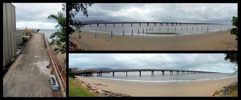
We drove past Victoria Mill (the largest sugar mill in the southern
hemisphere) on the way to Lucinda, and the bulk sugar terminal which boasts the
longest service jetty in the southern hemisphere, The
Sugar Jetty.
The jetty, completed in 1979, is 5.76km long and enables Lucinda to receive some
of the largest ships used in the raw sugar trade. The rain held off long
enough so we could walk around the foreshore, viewing the sugar terminal
building and the mega-long jetty. Signs on the foreshore warn of the
different poisonous stingers present in these northern waters, like the
box-jelly fish and the irukandji. At the boat ramps there's also warnings
of crocodiles and not to stand in the water whilst launching or retrieving
boats.
16-5-2014 Friday
We left the park this morning and drove to the nearby good boat ramp and put the
boat in. We were a bit uncomfortable as we didn't know the waterways and driving
out for a long way, we were only in around 1 metre of water, and it was high
tide. We finally worked out where the deeper water was but still didn't want to
go too far as there seemed to be lots of areas that could've been a problem for
us. We fished for a couple hours but caught nothing. It was quite overcast this
morning but slowly the blue sky started to show through. We were right next to Hinchinbrook
Island the world's largest Island National Park with unique wilderness
and World Heritage status.
After getting the boat out of the water and washing it down, we drove 63kms
north to the town of Cardwell(Q) and the Cardwell Van Park for 2
nights. On the way we stopped at a recently built lookout to view Hinchinbrook
Island and in the foreground, marine habitats, including fringing reefs and
seagrass beds, looking like smaller islands in front of the big one. Cardwell
was hammered by Cyclone
Yasi in 2011, and I remember seeing the news reports that showed lots of
luxury boats at the port, all washed up against each other. The caravan park
owner here says they're still doing repairs at the park.
17-5-2014 Saturday
Quite windy and rainy on and off today. During a dry spell we rode Harley a few
blocks down the road to see the impressive and well laid out Historic
Post Office and Telegraph Station. It was built in 1870 and is one of
the oldest buildings in North Queensland. The building has been entered on the
Queensland Heritage Register, the Register of the National Trust and the
Register of the National Estate of the Australian Heritage Commission. On the
same site are the former courthouse, the lock-up, and the old shire hall which
also date from close to the turn of the century. There are interpretive displays
designed to enhance the public's understanding and appreciation of the local
history of the Cardwell area, focusing on the role and operation of the Post
Office and Telegraph Station and the other government buildings on the reserve.
The Post Office tells the story of Cardwell and its place in the communications
vital to the development of Northern Qld. There were quite a few telephones and
related equipment for Dave to check out.
Next we rode down to the port to check out the boat ramp which was on the map,
but there wasn't any signage and we couldn't find it. It was fairly academic
anyway as the weather isn't very conducive to boating at the moment. The
channel, which runs between the mainland and Hinchinbrook Island and would
normally be protected and calm, was quite choppy as the wind seemed to be
blowing right up through it. We walked down the concrete jetty and around the
pleasant foreshore, which had to be completely rebuilt after Cyclone Yasi in
2011. We bought some nice prawns for dinner at the local seafood shop and
hurried home before the heavy
rain was soon to arrive.
18-5-2014
Sunday
We left the park this morning and drove 90kms to the small town of Mena
Creek(Q) and Paronella Park (not a caravan park but caters for some
camping) for 1 night. On the way we stopped at the town of Tully and visited the
(Big) Golden Gumboot with a big green frog climbing up the side. The boot
symbolises the town with the highest rainfall. The beautiful green landsape as
we've been driving in north Qld so far, certainly attests to the fact that
there's high rainfall. We climbed up inside to the top and had a 360 degree view
of the town. The height from the top of the gumboot is 7.9 metres, ands is also
the level of rain Tully got in 1950 when they had the big floods. The big sugar
mill is across the road and tours are run around mid-June when the harvesting of
the sugar cane starts. We plan to come back this way to take one.
The place only has a small number of camping sites and we're lucky we got in
early. At the end of the month, when the school holidays start, the place gets
quite busy. By late afternoon all the camping sites were filled. After setting
up in the early afternoon, we joined one of the 45 min tours of the park (run
half hourly) and got all the history of the place and the remarkable man who
built it. We had an early dinner at the nearby hotel (owned by the same people)
and then joined the 6.15pm night tour to see the the waterfall and castle
flood-lit, quite a different and lovely site. Our guide got us to turn off our
torches and showed us a firefly that flashes light on and off from its abdomen,
and a glow-in-the-dark mushroom. It rained on and off all day and in the
evening. The Park provides umbrellas for use during the tours and flashlights
for the night tour.
Paronella Park - an impressive place with an equally impressive history. Jose
Paronella arrived in nearby Innisfail in 1913, having sailed from Catalonia in
northern Spain to plan a splendid life for himself and his fiancee. He worked
hard for 11 years, creating his wealth by buying, improving and selling cane
farms. While travelling through the beautiful countryside he discovered a virgin
forest alongside spectacular Mena Creek Falls - perfect for his dreams. He was
quoted as saying "I have travelled the world twice and never have I seen
anything as beautiful as places you have in Queensland". He returned to
Spain, married, came back to Australia, and purchased the land of his dreams in
1929. Jose firstly built their home, a stone cottage. Then inspired by childhood
memories of Catalonian castles, he and his work crew set to work designing an
entertainment area. On 13 acres beside Mena Creek Falls he built his castle,
picnic areas at the lakeside, tennis courts, tunnels and bridges, and wrapped it
up in an amazing range of 7000 tropical plants and trees. These trees included
an avenue of impressive Kauris that tower now like cathedral spires in a sacred
forest. Jose also built a movie theatre which was transformed on weekends into a
huge ballroom with live bands, who entertained while a massive ball of mirrors
spun from the ceiling to reflect a dazzle of pink and blue lights.
There's a 47step grand staircase, a couple of ornate fountains, a tunnel through a
hill that now houses very small bat colonies, and a bamboo forest. North Qld's
first hydro-electric plant was built in 1933 to power the 13 acre park and the
castle grounds were ready to welcome the public in 1935. There were refreshment
rooms and changing cubicles for swimmers. Eventually a museum featured a
collection of coins, pistols, dolls, timbers and interesting keepsakes.
Paronella Park has gone through a number of tragic events with cyclones, fire
and accidents, and was not maintained for a period of 15 years until 1993 when
the current owners bought it. They envisaged reviving Jose's dream with his
appreciation for beauty and warm hospitality. They have created a museum in the
original home built by Jose for his family, and 2009 saw the refurbishment of
the original hydro turbine which once again provides power for the entire park.
Paronella Park is eco-certified and heritage listed. It is privately owned and
maintained and receives no outside funding. The owner Mark, greeted us on our
way in and mentioned that they had about 40 employees, so sounds like they are
being successful. They do rely on word-of-mouth for advertising and are doing a
fantastic job of keeping Jose's (very worthwhile) dream alive.
19-5-2014
Monday
We drove 118kms west and then north to Lake
Tinaroo(Q) and the Lake Tinaroo Holiday Park for 4 nights. We
checked out the boat ramp about 500 metres away, before checking into the park.
Lake Tinaroo is home to the Big Barramundi and there is a Barramundi Bash
here annually where people come from all over to compete. At the moment the
place is fairly quiet but will get busier next month. We stopped at Innisfail
for a quick look around and noticed all the magnificent old buildings still
standing. It rained on and off through the night and was still overcast and
fairly rainy today on our drive. Once we reached the park the blue sky started
to peek through and by the afternoon we had quite a few hours of sunshine. On
our drive we climbed upward and upward to the Atherton Tablelands. The
landscape was beautiful and green, abounding with sugar cane, banana and some
tea crops. The Cassowary Coast is the name given to the land stretching
from Cardwell to Innisfail and features lush rainforests, secluded beaches,
tropical islands, rugged coastal ranges and fertile flood plains. So far we
haven't actually seen an endangered and protected cassowary in the flesh yet.
20-5-2014 Tuesday
We put the boat in the lake this morning, nice not to have to consider tide
times. We drove Casa and the trailer back to the park as it's not far and we
could hook it back up to the electricity for the fridge. It was rainy and windy
with alternate periods of blue sky and sunshine, throughout the day. We put pots
in the water to catch some red claw but by the time we wanted to come back in,
there wasn't any in there yet. There's a better chance of them being in the pots
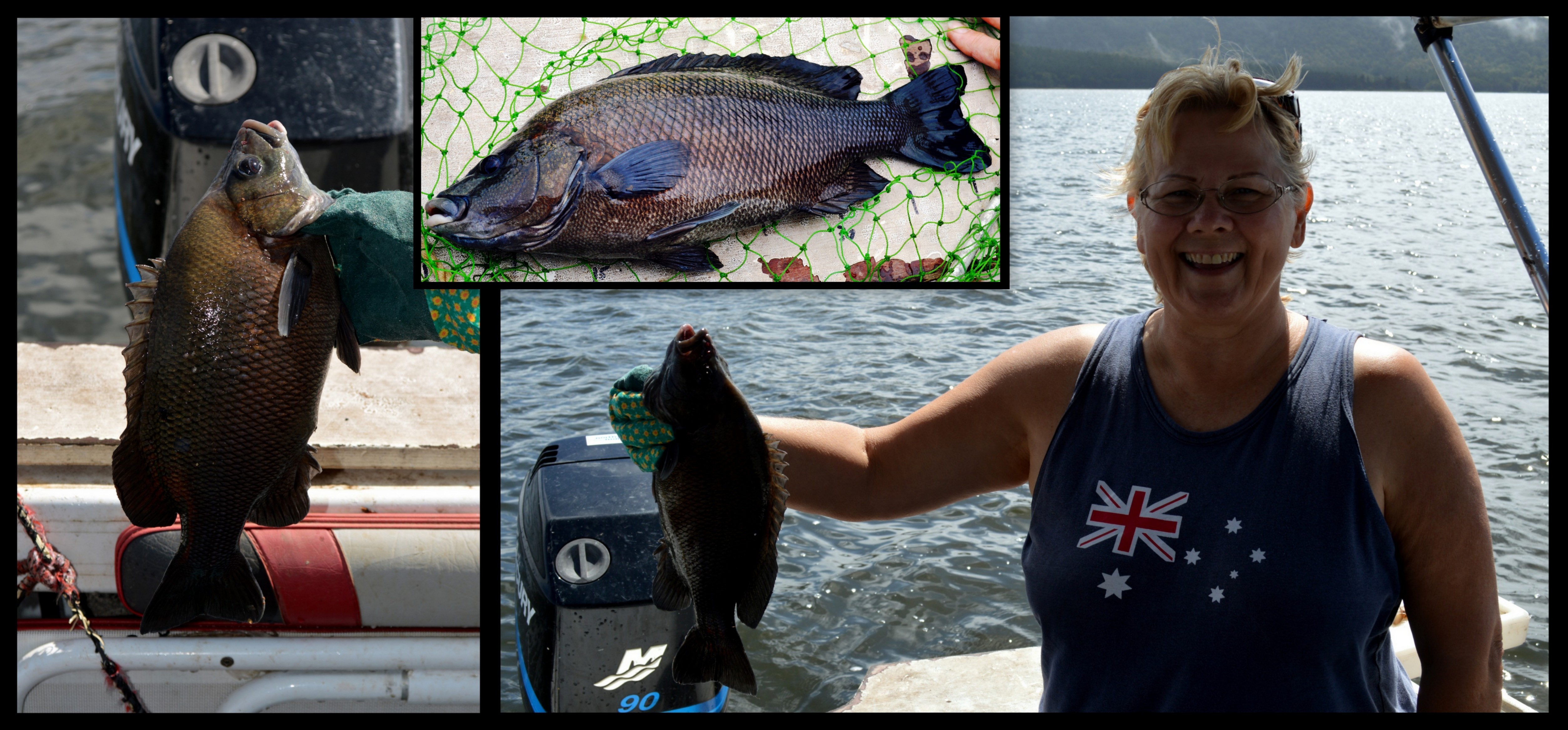
in the morning, after being left out overnight. I did catch a fish though, a big
Sooty
Grunter, and I was so excited. I've never caught such a big fish before and
never that type - it did us for dinner and it was nice. We got some bites but
unfortunately it's the only fish that we caught all day - usually it's Dave that
catches the dinner and I have to throw back the small ones I catch. We left the
boat in the water for the night - it's fairly quiet here at the moment so taking
the risk that it'll be ok.
21-5-2014 Wednesday
Was a bit less rainy and windy this morning and we went fishing again, but only
stayed out til lunch time. Only caught 1 small red claw, 2 prawns, and 1 fish
but it was a big Sooty Grunter again, caught by Dave this time (it's no bigger
than the one I caught yesterday even though he says it was). He
also caught a turtle! As he pulled up his line thinking he had another fish,
up came the decent sized turtle. It was caught on the hook so we used the net to
get it in the boat. We freed it and it speedily swam away. We moved the pots to
a new location hoping we'll have more success tomorrow.
22-5-2014 Thursday
We went out early this morning, 7am, to see if we could have better success with
the fishing - no! After a while Dave caught 1 big Sooty Grunter again, (that's 3
in 3 days) but nothing else for either of us. We're beginning to think there is
a 'natural' bag limit of 1 Sooty Grunter per boat per day! Don't think we'll
have fish again for dinner though, even though it was nice. And there were no
red claw at all in any of our 10 pots! Very disappointing! When we'd booked into
the park, the receptionist showed us a petition that's there for people to sign
to restock the red claw in the dam, but we doubt they'll have much luck as it's
not native to here just like Somerset, and therefore considered a pest. Thing is
that's why people go there, to catch red claw! Ironic! Anyway, we moved them to
yet another location - chances are that you need "local knowledge" and
we might find them just when it's time for us to move on.
23-5-2014 Friday
This morning we left the park and dropped Casa and the trailer down at the boat
ramp, while we drove the boat out to pick up the pots we'd left out overnight.
There wasn't 1 red claw in any of them! After loading the boat back on the
trailer we drove 35kms south to the town of Herberton(Q) and the Wild
River Caravan Park for 1 night.
We stopped at the town of Atherton first and walked around and then I went to
see the Crystal
Caves. It was great and of course there was the big gift shop at
the front that had all sorts of jewellery made with the crystals as well as
other interesting things (eg. bookends) made with the halved geodes.
Geodes are produced when air pockets form in volcanic lava. Over time crystals
form in the cooled air pockets with the outer shell being the cooled and
hardened larva. Dave didn't want to go in so I went on my own. It's right
in the main street of Atherton and the caves are man-made by this guy who's
crazy about crystals - there were wonderful specimens from all over the world.
There were more than 600 crystal formations and fossil specimens on display.
One type of crystal from India looks like cotton balls, all round and fluffy but
the blurb said they're not soft, quite hard and very fine - you have to be
careful not to get them in your skin. As you walk around you can touch all
of the ones that are exposed, mounted on the walls, but some are behind glass,
like the cotton balls one. There was a Crystal Fountain made with 4
tonnes of Rose Quartz! Also on display was the Empress of Uruguay,
apparently the world's biggest Amethyst Geode, standing 3.5 metres tall and
weighing 2.5 tonnes. The thousands of crystals she displays are rated
"AA jewellery quality". Another display, an Ancient Chinese
Sculpture, (blue in colour) is a major piece that weighs close to 50 kilos,
towers 47 centimetres high and thought to have been made over a period of a year
or more by an expert artist and commissioned by someone of great importance at
the time. Sculpted from a single large piece of beautiful Lapis Lazuli, this
carving is believed to be from the Chinese Qing dynasty (AD1644 to 1912).
24-5-2014
Saturday
We left the park this morning and drove a few kms down the road to the Herberton
Historic Village. It was very impressive and we enjoyed spending about 5
hours wandering around the 16 acre property, especially as this was the first
beautiful sunny day with absolutely no rain/showers whatsover in what seems like
quite a while. Showcasing Australia's rich and diverse pioneer history, the
Historic Village is testament to an era that is long gone. The Village collects,
preserves and displays fascinating historical exhibits from across Australia.
With more than 50 restored period buildings housing unique Australia
collectibles, turn of the century machinery and small engines, motor vehicles
and thousands of genuine antiques from the chemist to the grocer, it is the most
significant outdoor museum in Queensland. This is what the brochure says but
we've seen a few of these type of villages as we've travelled in OZ, and we feel
this is the best so far - it really is worth a visit. The man who started it all
at the tender age of 6 and kept collecting all through his life, was called
Harry Skennar. He passed away in 2009 and the new owners seem to be just as
enthusiastic about preserving and expanding the place as Harry.
One of the exhibits was the 'Telephone
Exchange' and there were quite a few phones in there. When Dave looked at
them he recognised 5 of them (like his children), and that they were a sale he'd
made a while ago! By the time we left it was mid afternoon and we abandoned our
plans to drive to our next planned destination so we went back to the Wild
River Caravan Park(Q) for 1 more night which we were happy about anyway as
it's a nice park.
25-5-2014
Sunday
We left the park this morning and drove all up, about 54kms to a number of
places, ending up at Lake Eacham(Q) and the Lake Eacham Caravan Park
for 1 night. This park is quite small and has only 7 camping sites, as well as
some cabins, but it is nice and quiet. When we pulled up and set up we realised
we had some company - a chicken with 3 small baby chicks, some turkeys, some
females and 1 male with its big impressive fanfare tail feathers, guinea fowls
and some ducks, the big white domestic ones. They obviously get thrown some food
from the customers.
On the way we stopped at the town of Yungaburra,
a nice feel town, where we wandered around checking out all the historic
buildings. Then we drove a few kms to the Yungaburra
Avenue of Honour,
located on the southern shores of Lake Tinaroo, and opposite a caravan park
where customers have a wonderful view of the lake. There were a few people
enjoying Sunday, picnicking and boating on the lake nearby. The 250 metre Avenue
was opened in June 2013 and is lined with Illawarra Flame Trees, which will
display a spectacular show of flame red blossoms each year from October to
December, encompassing Remembrance Day. Located within the Avenue is a
sculptured set of wings in full flight, depicting the contributions made by all
services, and symbolising the undaunted spirit of the Australian Digger. This
living Memorial commemorates the courage and commitment of those who served and
is dedicated to the memory of the young men who made the ultimate sacrifice in
the fight against terror in Afghanistan. A lasting tribute to the unsung heroes,
the bomb detection dogs, is positioned in the gardens adjacent.
Driving further back out of town, we visited the unbelievable Curtain
Fig Tree. Over a very long time (but nowhere was it mentioned on the
signs just how long) the young fig has climbed up a high tree, engulfed it, the
host tree has fallen against another tree and stayed on a lean, and the fig's
downward growing roots to the ground have resulted in what appears to be a giant
curtain (of roots). It reaches quite high up and is a really impressive sight.
We could see staghorns, elkhorns and ferns growing very high up on the limbs,
and the sign told of the wildlife supported in the fig, both by day and night.
Onward we drove to Lake Barrine where there was a teahouse and
cruiseboats on the lake. We were told that there is no access for boating and
skiing at Lake Barrine anymore - they have to go to Lake Eacham or further. A
short walk took us to the Twin Kauri Trees, two 1000 year old forest
giants, 45 metre high straight-trunked trees with a 6 metre circumference.
We continued on to the caravan park which is 1 km from Lake Eacham. We will
visit it tomorrow when we leave. Both Lake Barrine and Lake Eacham are crater
lakes, unlike Lake Tinaroo and others that are made-made by damming rivers.
These crater lakes were formed when underground water became superheated causing
massive explosions. A continual series of these explosions occurred, each a
little deeper than the last. The craters became progressivley deeper and wider.
Eventually the explosions stopped, sufficient groundwater returned and the lakes
formed in the craters.
26-5-2014
Monday
We left the park this morning and drove 54kms north to the town of Mareeba
(Q) and the Tropical Tablelands Caravan Park for 1 night. Not far
after we left the park we stopped to look at Lake Eacham. It was a lovely
turquoise colour and quite tranquil. Nice recreation areas have been developed
with BBQs, tables and seats right in front of the swimming access to the lake.
On the way in to Mareeba we stopped at the tourist information centre to make
enquiries and found they had a Mareeba
Heritage Museum starting inside the centre, and it was great. We
unexpectedly spent 2 hours wandering around and enjoying the displays. It
reminded me of the Herberton Historic Village we'd been to a few days ago but on
a smaller scale. A lot of work has gone into the displays, built and also
maintained by a band of volunteers with most display items being donated by
local residents.
Inside the centre some displays included Aboriginal, Early Settlers, Mining,
Communication and Media (more phones for Dave), Rainforest. Outside one were
Butcher Shop, Saddle Shop, Blacksmith, Rodeo display, Rail Ambulance, and the
Tobacco Industry which was big here until the early 2000's. There was a normal
railway carriage you could walk through, showing how it was decked out in its
day. There was even an outback 'Dunny' (toilet for younger ones reading this) -
the door was shut but you could see the shoes and the bottoms of the trousers
under the door, and periodically you'd hear a voice say 'Gee it's hot in here!'
Ha ha.
Mareeba is the largest town on the Tablelands and is Australia's coffee growing
capital, with over 70% of Australia's coffee crop being grown here. Afterwards
we did a big grocery shop and made our way back to the park.
27-5-2014 Tuesday
We left the caravan park this morning and drove 64kms north and then east to Manoora
a suburb of Cairns(Q) and the Cairns Villa and Leisure Caravan Park
for at this stage, 21 nights. 12 of these nights, from the 1st June, Casa and
the boat will be in storage here while we do our trip to the Cape in a 4WD
campervan. Before leaving Mareeba we paid a visit to a place called Coffee
Works, where there is an amazing collection on display, of coffee making
machines, plungers, filters, percolators, samovars, espresso machines, grinders
and related memorabilia, from all over the world. Many information boards
chronicled the history of coffee and its journey through time and many
countries. Coffee was first discovered in Ethiopia, and the first coffee planted
in Australia, was at Kangaroo Point in Brisbane in 1832. There were many old
metal coffee machines, mostly from Italy, some looking like something out of a
science fiction movie. The oldest and rarest piece in Coffee World was a French
grinder, circa 1750, totally made of wood, even the screws - the exception was
some metal inside used for the grinding of the beans.
Upstairs was a smaller, albeit still extensive, display of tea making equipment
and memorabilia. There were many different styles of teapots and some 'Teasmade'
machines that were programmed to automatically brew your tea at a preset time in
the morning, so you can wake up to your tea already made, by your bedside if you
so desired. Also on display were 2 big porcelain teapots, each with 2 spouts, so
you could pour 2 cups of tea at the same time. Apparently these were used by the
Lipton tea ladies in tea shops in England. Part of your entry ticket included
unlimited tastings of various coffees, teas, chocolate and coffee liquers, and
several flavoured chocolates (like chilli, coconut, macadamia) that they make on
the premises, in their boutique Chocolaterie. We spent a couple hours viewing,
tasting and then having some lunch.
28-5-2014
Wednesday
Washing day today and some odd jobs. In the afternoon we rode Harley a few kms
down to the business, Cheapa Campervans (part of Apollo), to check out the 4WD
campervan we're hiring to go to the Cape, and to pay the balance of the money
owed. The fridge is only the size of a medium esky and there's no freezer, so
will have to do a bit of thinking in the food management area. We've downsized
from our house to Casa, which was a good practice as we now need to downsize
from Casa to the smaller 4WD camper - mmmm interesting.
29-5-2014 Thursday
I went to the hairdressers this morning not far from the park, to make myself
beautiful for our rugged trip to the Cape. The hairdresser was a young and very
nice Sri Lanka lady and we got on very well, no difficulty in finding something
to talk about. Dave picked me up on Harley afterward and we rode into the CBD to
the Tourism Office. We booked a couple of trips - one on a boat trip to the
Barrier Reef with a 10 min helicopter trip over the reef; and the second one on
the Kuranda Railway and Skyrail when we come back from the Cape - all in all,
quite an expensive couple of days (yesterday with camper, and today). After that
we walked around the esplanade and saw the popular Lagoon, a popular
freshwater swimming pool right near the open ocean. It appeared similar to the
one at Southbank in Brisbane, and also had a lifeguard on duty.
30-5-2014 Friday
We got up early this morning for our big trip to the Great Barrier Reef
about 90 mins out of Cairns, with the travel mob called Reef Magic - it was
great. We had to be waiting for a bus pickup across the road from the park at
7.55am but it didn't turn up. After calling up they realised there'd been a
mistake made, and they sent a taxi for us and we got there on time. It was bit
rainy at the beginning of the day but when we got out to the reef, it was quite
sunny. We rode the big swells on the ocean and a few people had to go outside to
use the sick bags. Dave and I had taken a couple travalcalm tabs just in case.
Once out there, people could go snorkelling in a cordonned off area and everyone
looked for a favourite resident, Wally, a 40 kilo beautiful blue Giant
Maori Wrasse. His fillets would feed us for a month! This part of the reef is
classed as 'green' so no type of fishing is allowed and you can't anchor your
boat. The tourist boats are tied up to a large pontoon called Marine World,
specifically placed for this purpose. Whilst snorkelling you aren't allowed to
walk on the coral at all. Dave said he came here about 35 years ago and
remembers that you could walk on it - they told people to make sure they brought
suitable shoes (like their volleys).
Dave did see Wally when he went snorkelling (I didn't feel like it). You could
also go scuba diving and you didn't have to have any experience - they would do
an introductory session. We'd pre-booked and went on a 10 min helicopter ride
over a portion of the reef, with 2 other customers and the pilot. It was very
special seeing the reef from the air. Of course what we were seeing was only a
very small fraction of the whole reef. Looking down we even saw some big
turtles. Rides were also conducted in a glass bottom boat, and also a
semi-submersible with the windows at the sides. We saw lots of beautiful fish
and coral of many different types and colours. It truly was an amazing
experience. We were out all day, leaving at 9am and getting back at 5pm. A
lovely buffet lunch was included and morning and afternoon tea. The ride back
was a lot calmer but the sky was blackening up again and there was some heavy
rain.
31-5-2014 Saturday
We spent the day working out what we're taking to the Cape and that's about it.
There was stuff everywhere inside Casa, ready for the camper. Did a little bit
of shopping for the remaining necessary supplies and bought takeaway for dinner.
1-6-2014 Sunday Day 1 Start of our Trip to
Cape York
We rode Harley to the campervan hire place this morning. After getting the
necessary instructions (and having a discussion about a discrepancy with the
deposit paid amount) Dave rode Harley back to the park and I drove the 4WD
campervan. After loading up (it was surprising how much storage space there was)
and securing Casa and the boat, we set off. Firstly we drove to a garage and
fuelled up the 2x20 litre containers provided, in case we happen to need them.
We then drove 75kms north to the town of Mossman(Q) and the Mossman
Riverside Leisure Caravan Park for 1 night - and time to work out the camper
and how we're going to manoeuvre in such a small space inside. It was different,
going into the reception at the caravan park and not having to ask 'do you have
room for us?', pointing to Casa and the boat. We can fit anywhere.
On the coastal drive here, we stopped to watch a young guy being taken for a
hang gliding session. We'd never seen it before. It looked a bit scary to us. We
watched as they ran off the cliff (with the triangular glider) and were swept up
by the winds. They floated around for ages, making turns and rising and falling.
I think the session was going to be 30 minutes so we went on our way. They land
on the beach below - a nearby sign specified that no landings were to be back up
on the launch area - it was too close to the busy road for that to be an option.
A 65 year old lady was waiting for her turn next! Crazy woman! although it did
look like a whole lot of fun. Plenty of people were stopping to check it all
out. Next we took a 6km detour out to Port Douglas, a very touristy
place, very popular with overseas tourists. Driving in to the town, there was
one holiday accommodation place after another! And in the town, the car-lined
streets had one tourist shop after another, in amongst all the eateries. It
reminded us a lot of Sanctuary Cove down toward the Gold Coast way. After
parking in a busy street, in a normal car park space (which was rather novel for
us), we had a bit of lunch and then walked around. The town is on the water and
we wandered down to look at all the fancy boats in the marina. There was a
novelty train called the Bally Hooley Railway which actually runs back
and forth between Port Douglas and Mossman - a good way to get about, especially
if you wanted to have a drink. There'd been a big markets on but was wrapping up
as it was approaching mid afternoon.
2-6-2014 Monday Day 2 Cape York Trip 2-6-2014 Monday Day 2 Cape York
Trip
Left the park this morning and drove a few short kms to see the local Mossman
Sugar Mill for a photo but not open for tourists. Then to the Mossman
Gorge which really surprised us. We expected this to be just a short walk to
view the gorge and then move on. There was a big centre there of administration
offices, National Park offices, a shop, art gallery and training centre, all
seemingly run solely by Aboriginal employees. It was about 2kms to where the
gorge walks start. You could walk it or pay to catch the bus which we did. There
was an elevated timber walkway over the deeper parts and taking you through
beautiful rainforest with thousands of trees, plants, vines, mosses, etc. There
were some lookouts to view the fast flowing Mossman River and the Jungle
Perch fish or Flagtails because of the blotches on the tails. One lookout had
the orange warning webbing around it as it had been damaged by floodwaters
and/or cyclones, and had actually been carried several metres from its original
position. Water gushes over the large rounded boulders creating rapids but I
don't think riding these rapids would be a good idea - too many rocks. The signs
warned of Cassowaries but we didn't see any, only 1 brush tailed turkey that
ignored us while it clawed the ground for food. We walked over the sturdy Rex
Creek Suspension Bridge spanning the river. The original suspension bridge
(now gone) was built by Army soldiers because this place was too hard to
transport the necessary building supplies by vehicles. The soldiers carried the
supplies by foot. A plaque at the bridge's end acknowledges their enormous
efforts. There was a 2.4km rainforest circuit track but we decided not to do
that.
On our way again a bit after midday we continued on the coastal road, travelled
the short distance over the Daintree River on the Daintree River Ferry,
through the Daintree Nat Pk, stopped at Alexandra Range Lookout
which gave a wonderful view out to the Coral Sea and the mouth of the Daintree
River, and to Cape Tribulation. We stopped here briefly to walk out to
the beach area but other than holiday accommodation we didn't see too much here.
On we continued, to the point that warned only 4WD vehicles should continue. We
travelled 25 kms, crossed a few creeks, one was quite deep, and drove over some
quite rough, rocky, and steep roads. We continued on to the where the Wujal
Wujal Aboriginal Community was located and the wide Bloomfield River.
This whole road from Cape Tribulation up to the sealed Mulligan Highway (and not
too far to Cooktown thereafter) is called the famous Bloomfield Track.
Alcohol restrictions exist at this community - i.e. NO Acohol but bona
fide travellers (like us) may pass through here with restricted amounts of
alcohol (such as 1 carton of 30 cans beer and 2 bottles of unfortified wine) as
long as they don't intend staying here. At the Bloomfield River is a causeway
and the most difficult and dangerous crossing for us today. In one of the travel
books was the statement that a causeway had been built which made the crossing a
lot safer than it used to be - it still looked pretty unsafe to us '4WD
non-enthusiasts'. Alongside the causeway was a big concrete bridge, only about
two thirds finished - we'd wished it was already finished! A few cars were lined
up, waiting on the side of the road and we found out that the water was too high
yet to safely cross. The water wouldn't be low enough until about 5.15pm and it
was 3.50pm now, so we sat around and had a cuppa and waited. One cause for
concern with the causeway was that there seemed to be a big hole in the
concrete, a dark patch underneath the flowing water.
No-one was making a move to cross and some guys said they weren't going to cross
as it appeared too uncertain, even though the force of the water had visibly
dropped (still plenty of water on the causeway though). Then at around 5pm a
land cruiser came down from the other side, and without hesitation, drove into
the water, across and back up our side. He didn't seem to have any problem at
all, even at the area where the hole seemed to be. One of the young observers
said that "the guy was rolling a smoke as he was driving across"! He
must've been a local! So now the people decided to cross. We waited until a few
went across and especially one car that had the same height off the ground as
us. They were all getting across ok. It was about 5.50pm and starting to get
dark, and Dave said if we were going to cross, we'd better do it soon,
especially as people who'd gone through were waiting on the other side, watching
others come through, so if we got into trouble, there were people who could help
or raise the alert. We packed up our stuff and went for it! We went over the
holey area without any problem. We kept trudging but as we got about three
quarters of the way it got noticeably deeper (which we'd noticed with other
vehicles). 'Casa Junior' started to falter, with water coming up over the
headlights and the bonnet (as had happened with other cars), and we thought she
was going to stop, but luckily she chugged through the water. We weren't quite
up the steep concrete part going out on the other side, and had to stop, but we
were out of the water. A fellow experienced driver said to put it in low range
which we did and we climbed up ok. We sighed a sigh of relief! Drivers and
passengers of the other vehicles waiting on the other side, watched our journey
and as we came up out of the water, they all cheered and clapped - and so did
we! It was great but scary! We stopped at the side of the road and when I opened
my door water, that'd seeped into the car at our feet, flowed out! Everything
was ok and dry up in the habitat area though except for the first step,
thankfully. But I don't want to do that again!
We talked a bit to the other drivers and I said we need a drink after that. One
said 'Yeah, we're going to the Lions Den Hotel' where camping is also available.
When I asked how far that was, he said about 40kms! So off we went too. We ended
up driving in the dark which we don't normally do, especially on rough 4WD
roads, but at least this part of the road wasn't too bad. There were however a
few really muddy, slushy bits where there was a bit of sliding, but we finally
got there without incident. We arrived about 7pm at the Lions Den Hotel
(for a welcome pizza and a hot shower) at the small town of Helenvale(Q)
on the Bloomfield Track, for 1 night. This hotel reminded me a bit of the Kynuna
Pub we stayed at last year, with lots of writing all over the corrugated tin
walls from customers, and memorabilia hanging from the roof. We are only 4kms
away from the main highway that goes to Cooktown (30kms away), and 65kms north
of Cape Tribulation. We ended up driving a total of about 135kms today.
3-6-2014 Tuesday Day 3 Cape York Trip
Not such an exciting day today as it was yesterday, but that's ok with us. We
left the hotel and drove 30kms north to the town of Cooktown(Q) and the Cooktown
BIG 4 Caravan Park for 1 night. I drove as it was all bitumen from here.
Before booking in to the park we visited the Captain Cook Museum,
originally a Sisters of Mercy Convent/school built in 1889. Cooktown was of
course named after Captain Cook who landed here in 1770. The highlight of the
gallery is the original anchor and cannon from Captain Cook's ship, the HM Bark
Endeavour, jettisoned from the ship in 1770 after their catastrophic grounding
on nearby Endeavour Reef. Integral to Australian history and identity is the
interaction between Cook and the local Guugu Yimithiir people - the most
extensive he experienced in Australia - and this story is also told from both
perspectives. There are tales from the Palmer gold rush and a display dedicated
to the rich Chinese heritage of the region. Apparently there was around 18,000
Chinese who made the trek here to find their fortune and a new life. The
Indigenous Gallery gives an unmissable insight into the culture and history of
the Guugu Yimithiir people. While at the museum a few of the cars that went
through the causeway yesterday turned up. One of the guys had taken some photos
of us going through the water and kindly emailed one to us, which was great!
Next we drove up to the Grassy Hill Lookout and Lighthouse. It was
up a steep winding bit of road, unsuitable for caravans or our big Casa, but
easy for Casa Junior. There was a magnificent 360 degree view of the town, the
mouth of the Endeavour River and the same view out over the open ocean that
Captain Cook took to decide his next sailing movements. We drove through the
main street to see all the old buildings. One of the signs told of the damaging
cyclonic weather and mentioned how many years ago, the Sovereign Hotel which was
partly blown away, was thereafter referred to as the 'Half Sovereign'! Ha ha! We
visited the James Cook Statue on the foreshore - the sculpture marks the
site of the re-enactment of Cook's Landing, which takes place every June during
the Queen's Birthday weekend. Queen Elizabeth II came to Cooktown in 1970 to
mark the 200 year occasion of Cook's Landing. A Chinese Monument
commemmorates the contribution made by Chinese workers in the Gold Rush era. We
bought some prawns from a roadside local vendor and had a nice sandwich for
lunch.
I cooked in the camp kitchen tonight for the first time, ever. I always cook in
Casa's good size kitchen but the campervan (Casa Junior) has an external fold
down BBQ - better in the camp kitchen where there's more room, a proper stove
and sink and easy washing up facilities. The only problem with the camp kitchen
is if it's busy. Tonight we were mostly on our own which was really good - we
could hog the tv.
4-6-2014 Wednesday Day 4 Cape York Trip
We left the caravan park this morning at 9.15am and drove 389kms north/west to
the town of Coen(Q) and the Exchange Hotel (out the back camping
with quite a few others probably also going to the Cape or back from) for 1
night. We arrived at 3.15pm so it'd been 6 hours since we left and we stopped
about an hour all up, for fuel at the town of Laura, and then later for lunch (a
lovely 'burger with the lot') at the Musgrave Telegraph Station. This
station was one of the many repeater stations for the Telegraph Line, and we've
seen several now in our travels. There was only a small but comprehensive
display on one wall. Just before we got to the telegraph station some people on
the road were indicating for us to slow down. When we reached them they said
there'd been an accident just a little further on - we could go through but just
go slow. We saw a vehicle on its wheels but with the windscreen and roof badly
damaged, may have been a rollover. We'd noticed a landing field just next door
to the station and while we were waiting for lunch, we noticed a Royal Flying
Doctor Service plane arrive, probably for a crash victim - Dave said he saw a
lady being treated not far from where we were sitting but she didn't seem to be
badly injured.
The road so far has been pretty good, well graded, but I believe further up it's
not as good. I don't think I'd like to be driving on them in the wet; probably
very slippery. When you were behind a car or cars/trucks coming from the
opposite direction. there was a lot of dust and sometimes it was hard to
see.
Toward the end of our trip we saw ahead of us going in our direction, 3 cyclists
(bicycle), peddling along getting covered in red dust every time a vehicle
passes from either direction, and they weren't wearing any masks! They turned up
here for the night. Whilst deciding on where we'd stop for the night at the back
of the hotel, we noticed some trees, black with bats (flying
foxes) hanging in
them, and made sure we didn't go anywhere near them. We could smell them from
where camped. Before we could do anything much I did fairly quick wipe out of
the back of the van as some fine red dust had made its way in - wasn't going to
bother with a big clean until we get home as there's plenty more dirt roads to
tackle yet.
5-6-2014 Thursday Day 5 Cape York Trip
We left at 8.30am and drove about 462kms north to Seisia Beach(Q) (14kms
past Bamaga) and the Seisia Holiday Park for 2 nights. We arrived about
4pm and only stopped for fuel at the Bramwell Roadhouse and a snack at the Moreton
Telegraph Station, so we had a long day, driving for about 6.5 hours. I took
a turn today, driving for a couple hours. Surprisingly once we turned off the
main Peninsula Development Road which runs to Weipa, the dirt road was quite a
bit better even though it was a lesser road - probably due to the fact that
there's not as many heavy vehicles using this road. There were still a few 4WD
moments though, with some washed out areas and some quite rough patches. The
telegraph station was another repeater station. It didn't have much of a display
but it did have about 3 Oppenheimer
poles, still erect, and with some insulators
on the top crossbars, so that caught Dave's eye. There was camping available
here but there was no power for sites.
We saw lots of cattle today, some on the side of the road and sometimes some on
the road. There's a track called the Old Telegraph Road and it's a really rough
track, for 4WD enthusiasts. We're not allowed to take the rental vehicle on this
track at all. Once we reached the Jardine River there was a ferry that
takes you across (for $129 return, around what it costs to catch the barge to
Stradbroke Island which takes about 45 minutes), which takes about 1 minute,
pulled across the river by an diesel powered cable. The high cost is explained
as covering maintenance of the ferry service, visitor facilities, Ranger
facilities and land management and information. Once on the other side alcohol
restrictions are again in place. We also saw here lots of wild horses, just
grazing at the roadsides and they looked fairly healthy. A Qld Police brochure
we were given at the ferry place, about the Northern Peninsula Area (NPA) where
we now are, warns of being aware and alert to their skittishness and their
tendency to run out onto the roadway at any time. They also warned of the Tiger
Sharks and the Bull Sharks that inhabit these tropical waters and known to be
aggressive and unpredictable; the dangerous stingers such as the box jelly fish;
and crocodiles found from the beaches to the waterways - warned to camp as far
away from the water as possible.
On the way here today and yesterday, we passed several areas where roadworks
were being carried out. The summer is their 'wet' season which means floods and
cyclones and lots of damage being done to roads, and so during the dry season
and tourist times, the roads need to be refurbished. This is common all across
the top end of Australia.
Once we set up camp, we relaxed outside the van in the cool, and later walked to
the end of the park and onto the beach. We were looking out onto the Torres
Strait and the islands beyond - a lovely site. The amenities blocks in several
parks where we've stayed, have had some interesting comical names for the
'Ladies' and the 'Gents'. At this park the Gents shows a picture of a mango tree
with yellow mangoes on it and the words 'Man-Goes'. The Ladies shows a mango
tree with no mangoes on the tree and the words 'No Man-Goes' - Ha ha! Quite
clever.
6-6-2014 Friday Day 6 Cape York Trip
We went on an all day tour this morning, starting at 8.15am at the wharf, and
back at 4pm. We joined 12 others (not counting the driver) on a Seisia
Fishing Charters boat to Thursday Island and Horn Island. It
took about 1.25 hours to get there, over beautiful, clear blue/green waters. The
Torres Strait is Australia's most northern frontier, stretching from the
tip of Cape York to Papua New Guinea, covering over 200 islands - most of which
are uninhabited (18 are inhabited). Thursday Island, one of the smallest
islands, is the most inhabited and is the main administrative centre for the
Torres Strait, with around 60 businesses and 60 different government
departments/authorities. Dave and I walked around the small town centre looking
at the businesses and churches - there was a funeral service just coming out of
the church, and the people were wearing bright, colourful, floral outfits
(unlike the black we usually see our services) that put me in mind of Hawaii's
people. Later I found out Torres Strait Islanders' (TSI) were of Melonesian and
Polynesian descent so that fits.
We visited the Gab Titui Cultural Centre which provided a unique insight
into the region's vibrant art and culture. The main gallery displayed artworks
that included sculptures, headdresses, intricate lino-cut prints, wood carvings
and paintings, as well as jewellery made from local materials such as pearl and
sea shells. There was also jewellery made from small, brightly coloured beads,
putting me in mind of the jewellery made by the African people. Across the road
on the esplanade, were metal sculptures of the big, beautiful, green turtle
which is a loved meat here, and 2 big halves of the 'Pinctada
Maxima' pearling
shell. We'd learned about the pearling industry in Broome last year but hadn't
realised it was a thriving industry over this side of the country too. This
meant that this area had a big presence of Japanese people here too, who were
very good divers.
We'd been split into 2 groups to go on an island tourist trip with Frank in his
9 seater taxi. We were in the second group which we did after our walk around.
Frank is an older islander who was very entertaining and gave us some insight
into his culture, while he was driving and pointing out the various different
historical sites, churches, businesses, etc. He pointed out that they are
different to the Aboriginal people. He said Aborigines are nomadic, but the TSIs
are not. Our first visit was the Green Hill Fort
defence post with 3 big
guns pointed in different directions. Up on top of this hill we had a wonderful
view of the surrounding beautiful water and islands - would be nice to have a
house built up there. It was quite blowy up there. Our next stop was a Historic
Cemetery which also has a well maintained Japanese Pearl Divers' Memorial.
There were some pearl divers' gravesites at the entrance to the cemetery and
they were sadly overgrown and unmaintained. After our tour was concluded Frank
dropped us off at the Torres Hotel for our nice lunch.
Then we hopped back aboard the boat for a short trip over to Horn Island to see
the Horn Island Heritage Museum. During WWII Cape York was a key defence
point against the threat of invasion from the Japanese army. An American bomber
base was set up and thousands of troops were stationed in Cape York. Horn Island
was a fighter base and was bombed several times. Frank said there was still a
military presence in the TSIs but he didn't say exactly where - this is good to
know seeing as Indonesia is very close. The museum had an extensive array of
WWII memorabilia, old photos and stories. There were also a lot of TSI artwork,
carvings and cultural items. The wind had really blown up and our journey back
to the mainland was quite rough! Our boat was not a big ferry type one but one
suited to carrying only 14 people. It was enclosed but the front was partly open
which allowed water to spill through when a big wave hit us. The back was open
and some people sitting down there, got quite wet with the water that came in at
the back. The driver was a young nice man but the passengers were all our
vintage, and lots of jokes and laughter were going on during the rough trip
back. They sounded like they were boating people so were much more relaxed about
the rough ride than other people may have been. We were bouncing hard onto the
seats so Dave decided to stand up and we were at the front so his pants got
quite soaked. As we were sitting up front it was a rougher ride and when one big
wave bumped us up into the air and came down with a thud, my left foot hit a
foot rest and really hurt my ankle. I'm getting around with a limp at the moment
- hopefully it'll be much better tomorrow. When we arrived back on Cape York
there was a Quarantine Inspector there at the pontoon, waiting to inspect our
bags to make sure we hadn't brought any plants back on to the mainland. Even
though the TSI are part of Australia, there are restrictions about carrying
plant life back.
When we got back to the park which was next door to the wharf, Dave had a job to
do. This morning as we were leaving, I had inadvertently locked us out of the
camper! Dave had the keys (only 1 set was given to us) but there is a second
lock on the habitat door, for which we don't have a key (we found out when Dave
rang the company later). This 2nd lock has a lever inside to lock when we go to
bed - this is the lever I locked and then shut the door to see if it locked from
outside. It did, of course, but then we couldn't get back in. It was a stupid
thing to do and if I'd thought it through properly first, I wouldn't have done
it. Anyway Dave was able to hop up on a wheelie rubbish bin, neatly cut the
insect mesh over one of the windows in the vinyl part of the pop-up top roof and
climbed through - Voila! Good job he's had a lot of practice climbing up and
down the front of the boat on the trailer when we put it in the water. He then
used some cable ties to close the mesh again - it'll have to be mended properly
back at the company. After that we went and had our showers and sat down with
some drinks and nibblies. The rain showers held off until we were ready to go
back inside.
Some people in the park near us spotted a big black cockatoo in a tree. It's
called a Great Palm Cockatoo - it's black like others we've seen but it
has a big red patch up around its eye and its crest is what really intrigues me
and makes me like it the best out of all the black cockatoos. Its black
feathered crest rising up off the top of its head, is quite messy and ruffled,
giving it the appearance of being the crazy, maniacal but comical cousin of the
Black Cockatoos. I snapped away hoping to get some good photos.
7-6-2014 Saturday Day 7 Cape York Trip
This morning we left the park and drove 46kms to the 'TIP' of Cape York (Pajinka),
the northernmost point of mainland Australia! It was quite exciting and plenty
of people were doing it. We were surprised the road was as good as it was,
albeit with a few serious potholes and water carved deep corrugations. When we
arrived in the small car park it was interesting to see one car had been parked
halfway up a big boulder, as if he was in mid 4WD action. There was a shortage
of spots and I suppose he did it because he could - where else can you park like
that! From the car park there was 500 metres or so of rocky area to be climbed
over. It was an easy-moderate walk and I was determined to get to the actual
tip, sore ankle or not! (it was much better this morning so wasn't too bad and
we found a good straight stick suitable for a walking pole) There was a sign
there claiming its northernmost feature, and of course it was a popular spot for
everyone to have their photos taken. There were fantastic views out over the
Torres Strait. Not far around the western part of the Cape, is Possession
Island so named when Captain James Cook claimed the continent for England by
planting the Union Jack in this island's soil.
We then drove 250kms south, returning back over the 1 minute Jardine River
Ferry, to the Bramwell Junction Roadhouse for 1 night. Because of my
ankle, Dave drove all the way today, and was quite tuckered out by the time we
arrived at 5.20pm. Not feeling like cooking myself after such a long day, we
ordered hamburgers before they closed. On the way here we took a 2.7km detour to
the Fruit Bat Falls - contrary to the name they were beautiful and you
could go swimming if you wanted. A bunch of young guys in 4WD vehicles did so,
with much vocal enjoyment and beers in hands. We'd heard it was going to be a
fairly rainy day today but we only experienced a few shower, which was good due
to the unsealed roads.
8-6-2014 Sunday Day 8 Cape York Trip
We spoke to some of the people who crossed the Bloomfield causeway on 2/6 (they
stayed here at the same place overnight) - we keep coming across them here and
there, and we catch up on where we've all been. We left the roadhouse this
morning and drove 170kms south and then west to the mining town of Weipa(Q)
and the Weipa Caravan Park for 1 night. I heard that people come here
from all over because the fishing is good. We noticed quite a few of the people
in the park have boats. Bauxite is mined here, the main ingredient in aluminium.
The park is on the beach and not far, is the port for the big ships taking on
the bauxite. It is a really red substance. On the way in to town we saw a RAAF
base at a place called Scherger. We arrived around lunch time and after setting
up camp, we just sat and relaxed for a while - something we haven't had much
chance to do lately as we've been keeping in mind that we only have this vehicle
for 12 days, and need to make the most of it. A lot of this time is taken up
with just driving the long distances, so that time isn't physically demanding
but it's still tiring. It was a bit rainy as it's been on and off for days.
Seeing as we weren't rushed for time I decided to cook dinner early, around 3pm,
late lunch/early dinner. We'd brought some limited fresh veges that didn't need
refrigeration like potatoes, sweet potato, onions and carrot, but hadn't had the
time or inclination to cook them until today.
9-6-2014
Monday Day 9 Cape York Trip
We left the park this morning and drove 418kms south west to the Hann River
Roadhouse(Q). It took us about 7 hours (from 10am to 5pm) as it'd rained
fairly heavily last night and turned a lot of the gravel road in places, into
greasy slippery mush. We only stopped once for fuel and a pie around 1pm, and a
couple small sandbox stops, as we wanted to keep going and get as far as we
could today, in case it rained tonight or tomorrow. Dave drove all the way,
going only around 60kms per hour (instead of the 100kms) in a lot of places due
to the mush. We actually wanted to go another 75kms today to the town of Laura,
where the sealed roads start, but Dave had had enough by 5pm and so had I, even
as a passenger. We saw so many cars coming from the opposite direction, totally
covered in red/orange mud, sometimes even over the windscreen but we believe
that's because they were going a lot faster than us most of the time. We were
trying to take it pretty easy and not end up getting stuck and needing recovery
action by another vehicle, as we really didn't have any serious recovery
equipment ourselves.
We did do some slides in a few very muddy areas but luckily no problems. It was
a sunny day today fortunately and the roads had been able to dry out a little,
although not enough yet for some of the big trucks we saw parked at the side of
the road in about 3 different places, obviously waiting until the roads dried
out further. We saw one truckie walking from one truck to another with a beer
carton under his arm so he looked like he was finished driving for the night.
There were trucks at the roadhouse too that weren't going anywhere today or
maybe even tomorrow. The lady at the roadhouse said they had to wait a couple
days for the roads to dry out a little. The wet season has hung on a little
further this year - usually it's finished by the end of May.
Here at the roadhouse while we were setting up camp, we saw a beautiful single
male peacock roaming around, and also an
emu! It was pretty friendly letting you
get very close to it. Dave was having some peanuts, rustling a bag, and the emu
walked on over to him hoping to get something. Dave shooed him away because he
knows how they can just swoop in and try to take your food, which can be
dangerous with their big strong beaks. Later we saw some kids walking alongside
of the emu, and a boy about 10 yrs old, had his hand on the emu's back as they
walked along. An adult (presumably the father) with a camera was walking just a
bit behind them. I'm afraid I wouldn't have been so calm about my child being so
close to it.
10-6-2014 Tuesday Day 10 Cape York Trip
Left the roadhouse this morning and drove 324kms south east to the town of Mareeba(Q)
and the Tropical Tableland Caravan Park for 1 night. We stayed at this
park last month with Casa and the boat - the lady put us on the same grassy
spot. The road, for the first 75kms to the town of Laura, was unsealed and like
yesterday, it was still slushy in places. It didn't rain yesterday or last night
so that allowed a bit more drying out. It was nice to get back on to the bitumen
road permanently after that. The Laura area contains Queensland's most extensive
Aboriginal rock art. It ranks alongside the Kimberley and Arnhemland escarpment
as Australia's most important rock art regions. UNESCO rates the Quinkan region
as one of the top ten rock art areas in the world. At the town of Laura, we
spent about an hour and a half at the Quinkan Cultural Centre, which
showcases all aspects of Quinkan country, including its Aboriginal and
non-Aboriginal heritage and the natural environment.
One of the displays was about the 2 New Zealanders, who in 1928, drove their
Austin Martin called 'Baby' from Sydney right up the Cape York Peninsula and
even over to Thursday Island (by boat of course). Of course in 1928 there
weren't any roads up the peninsula, let alone unsealed ones like we'd just
driven on. This wasn't a 4WD vehicle, and we frown on anyone who takes a normal
modern day vehicle on these roads we've been on for the last 10 days. These men
of course, were made from the same material as the original pioneers, and could
do just about anything. The man at cultural centre said they do rock art gallery
tours but have had to defer bookings for about 3 days because of the recent
rain, making the 4WD roads too bad even for their vehicles. On the way to
Mareeba we drove past a free washing facility for trucks on the roadside, to
help stop the spread of plant/weed material, so we drove the camper through it
as it'd picked up a lot of mud underneath and on the sides on our Cape trip.
Dave used a brush to loosen the dirt and I drove through another couple times.
It moved quite a lot but we'll still have to wash the car properly to finish the
job. The camper has to be returned with no mud and reasonably clean. While we
were there finishing up we noticed 2 other 4WD vehicles similar to ours, also go
through the wash.
11-6-2014 Wednesday Day 11 Cape York Trip
This morning we washed the camper to get rid of all the excess mud and dirt
(we'd asked the lady of the park yesterday before checking in if we could do
that). We got a lot of it off yesterday at the truck wash down facility. We left
the park and drove 142kms south and then east to the small coastal town of Etty
Bay(Q) and the Etty Bay Caravan Park for 1 night. The small park is
right across the road from the beach, is next door to the Etty Bay Surf Life
Saving Club and is really the end of the road. To get out you have to turn
around and drive back out the same way. Dave said he came here about 30 years
ago with 2 of his sons for a surf carnival and the surf club was just a tin
building, not the modern clubhouse it is today, and didn't think the caravan
park was there. The tide was out when we arrived and we walked along the beach,
enjoying the lovely view. There were coconut trees on the beach edge along with
lots of other trees, some leaning over, seemingly undermined by erosion of the
sand. When the tide came in later the waves were quite loud, crashing in -
reminded me a bit of our times on Stradbroke Island.
Real excitement for us and others here were 2 cassowaries that came
wandering through the park looking for food. Apparently they live around here
and are frequent visitors. They had found a rubbish bag outside one of the
caravans and were slowly ripping it apart, looking for any tasty morsels. One
was an adult and the other was a nearly full grown chick (we're told), with the
start of the neck waddle, but it was still only a brown colour and had no bright
colouring or the hard head piece on top of his head yet. It was surprising to
see just how small the adult was - I thought they were a much bigger bird. They
appeared to me to be smaller than the emu. We were also told that the adult is
the father, the mother's part done with just laying the egg. We and a few others
were happily snapping away with our cameras. They can be very dangerous though
if threatened - we're told not to feed them. It was very apt that we saw these
birds today as we have just come back on to the Cassowary Coast!
On our way here we stopped at the dairy producing town of Malanda. There
was a cafe right next to the factory but tours weren't being run today - we
should've been here yesterday, or tomorrow, any week day except today,
Wednesday. They did however have a comprehensive little museum out back, with
lots of historical information boards of the original settling of the area by
the hardworking pioneers. There were quite a few personal family stories and the
progress of the dairy industry here, down through the last century. We drove a
short way down the road to the Malanda Hotel, a very big, beautiful,
timber structure, built in 1911, and had a lovely lunch. The public bar has a
big long timber bar and there is a function room with an impressive timber
staircase. Another customer (from Atherton) and I got talking and he said he was
told that this hotel was the biggest timber building in the southern hemisphere!
I wouldn't be surprised at that - it is an impressive size. We were also
surprised because there was no notation anywhere that it had burnt down sometime
in its history, like so many other old pubs we've seen in our travels. Walking
down the street Dave noticed a pair of starlings' nest above the doorway of a
shop, and it had 2 baby starlings sitting on the edge of it. The adults would
fly back with food, but before you saw them you'd see and hear the chicks start
raising their wings, open their mouths wide and start squawking. The adult
would swoop in, deposit the food in the babe's mouth and fly off, all within a
split second - barely time for a photo. Dave said as soon as he saw and heard
the babies start squawking he'd get ready to click the photo.
12-6-2014 Thursday Day 12 Cape York Trip
It rained pretty heavily last night and was still going this morning - the
ground was quite squidgey. We spent our last night in Casa Junior which we're
really happy about. Even though it was good for our trip, we were glad we didn't
have to clear stuff out of the way to pull the bed out every night and then push
it all back in the morning, and then there's the climbing up and down (into bed)
which is a feat in itself - lucky we brought our own little step-stool. We had
to put a tarp (lucky we brought one) over the front of the vehicle because when
it did rain heavily, water came dripping in onto the bed on Dave's feet! There
were quite a few other things that needed attention (made a list for the rental
company) and we felt the vehicle was really close to it being put out to
pasture.
We left the park and drove 105kms north back to Cairns and the park where we
left Casa and the boat - home sweet home! We've really missed her and all the
space! On the way we saw a truck turned on its side, on the side of the road -
couldn't tell how it happened. We noticed as we got closer to Cairns the rain
tended to ease a bit. Before getting back to the park we filled up the tank and
took advantage of having a smaller car and did a little shopping. Back at the
park we emptied the camper and while I put all the stuff away in Big Casa Dave
gave Little Casa a clean inside - thankfully the rain held off. The rental
company said they expected no mud at all and the vehicle to be reasonably clean
- they obviously do a proper clean before re-renting. At 4pm (it had to be back
by 4.30) I drove the camper to the rental place and Dave rode Harley - luckily
the rain still held off. After handing it back in, without any hassles, we
bought some takeaway for dinner and looked forward to a relaxing evening and a
decent bed.
13-6-2014
Friday
Rest day today, so we had a good sleep in after our last busy 12 days, and as is
usual for a rest day, I did the much needed washing and a roast dinner. The
clothes drier got a good work out today too as it was raining all day. Dave
spent most of the day catching up on the photos and organising them into the
travelogues - he got behind while we were away on our Cape trip. It was nice
slowing our pace for the day.
14-6-2014 Saturday
Kuranda Scenic Railway and Skyrail
This was a good day! We'd booked this trip over 2 weeks ago when we booked the
Barrier Reef trip. We had to be at Freshwater Railway Station this morning at
8.25 about 10 mins away, so we rode Harley there. The rain was lighter today and
cleared up later so was good. The Scenic Train ride was slow and pleasant,
making it easy to take photos, and took 1.5 hours to arrive at Kuranda station,
travelling through World Heritage listed rainforest in Barron Gorge National
Park. We had a 10min stop at Barron Falls Station lookout platform to view the
lovely Barron Falls, 329 metres above sea level with a drop of 265 metres.
We went through 15 tunnels and thick rainforest. The carriages were originally
made from Silky Oak timber and some date back to the early 1900's. Old framed
photos of the building of the railway, were hung from the ceilings.
When we arrived we walked around the station, adorned with many beautiful
rainforest plants. We had 4 hours to do all our sightseeing and firstly,
wandered down to the Barron River and took a 45 min Riverboat Tour. This
turned out to be a good move because it started to rain once we were on the
boat, and we were the only passengers for this first trip. The driver gave us
quite a bit of information about the rainforest and the place, and pointed out 2
freshwater crocodiles on the riverbanks which were covered with green plants - a
little bit harder to see than the crocs we saw on the muddy banks in Kakadu. He
gave us some bread to throw into the water to feed the ducks, fish and turtles.
Inside the boat, lovely Welcome Swallows had made their nests in the lifejackets
that were hanging in netting from the ceiling. They flew around, and in and out
of the boat, as we motored down the river. As they flew you could see the lovely
purpley colour down their backs.
The rain cleared for the rest of the day, showing off blue skies at times. We
walked about 100 metres up the road, through the town of Kuranda. There were
lots of shops and eateries, and the place was well patronised - of course, very
much aimed at the tourist market which would be the majority of the people here.
We saw several tour groups including Asian and Indian. We were told once the
holidays start (toward the end of the month) they place gets really busy - we're
so glad we've come through now. There were also 2 types of markets and you could
pay to go in to see Koala Gardens and Birdworld. We decided not to go in to see
either of them as it would probably take a lot longer than the time we had left.
The town was nicely laid out with lots of plants and trees that grew roots from
the branches, down to the ground. We wandered back down to the Kuranda Hotel
for lunch.
Afterward we walked a short way down the road to the Skyrail Rainforest
Cableway and lined up to catch out gondola back toward home. Our gondola
glided just metres over the canopy of Australia's World Heritage listed Tropical
Rainforests and were able to get off at 2 mid-stations, Barron Falls and Red
Peak. We had such a wonderful view from up there, overlooking the town and the
mountains in the distance. At the Barron Falls stop we viewed the falls from the
opposite side to this morning's train view. At Red Peak we walked around a
boardwalk, viewing the rainforest close-up. Several beautiful Kauri trees stood
straight and tall, with clumps of ferns, elkhorns and vines growing on them.
Arriving at the terminus of the skyrail, Smithfield, we walked through the gift
shop and out to wait for our bus, which transported us back to Freshwater
station and our beloved ride home, Harley. We got back home about 4.40pm and
felt quite happy with the day.
The Kuranda Scenic Railway
Construction of the Cairns-Kuranda Railway was, and still is, an engineering
feat of tremendous magnitude. This enthralling chapter in the history of North
Queensland stands as testimony to the splendid ambitions, fortitude and
suffering of the hundreds of men engaged in its construction. It also stands as
a monument to the many men who lost their lives on this amazing project. In 1873
the cry of 'gold!' echoed through the mountains. Primitive supply routes from
the coast to the swelling gold fields were slow and perilous. In 1882 a
devastating wet season brought misery to the blossoming townships. Supply routes
were impassable and thousands of people came close to starvation. A reliable
supply route had to be found. Legendary bushman Christie Palmerston was tasked
to find a route for a railway to link the rich mining belt to the sea. In 1886
construction commenced on one of the most ambitious railway projects ever
undertaken. Construction began with up to 1500 men (majority of Irish and
Italian descent) at a time armed only with picks, shovels and dynamite. Almost 3
million cubic metres of earth were removed form the unforgiving landscape to
build the 37kms of track from Cairns to Kurands. Officially opened in 1891 to
serve the bustling mining industry, the railway includes 15 hand-made tunnels
(the longest being 490 metres), 55 bridges and 98 curves.
The nearby Barron Gorge Hydro Electric Station was Australia's first
underground power staion. Construction started in 1932 with the power station
carved out of the rock within the mountain on the northern bank of the Barron
River. It began supplying electricity in late 1935 and generates 60 megawatts of
renewable green energy to the Queensland power grid.
15-6-2014 Sunday
Thought we'd have another rest day today, which we both obviously needed as we
both slept in this morning - it helped that it was fairly quiet here. Alas, I
have no washing to do as is one of my usual 'day off' past times but made scones
that I'd been promising Dave, and will do a nice dinner. It's overcast, cool and
miserable today, with an occasional shower, a good day to stay home and watch a
movie or read a book. There's no blue sky, some of which we had yesterday - so
lucky we'd chosen the Kuranda trip for yesterday.
16-6-2014 Monday
This morning we rode Harley 4kms to check out the local boat ramp as we're
leaving the park here tomorrow and thought we'd put the boat in to try our luck.
The ramp looks good for us. We continued on another 4kms into the Cairns CBD
where we wandered around to check out the town and any places of interest. We
spotted the heritage museum but a sign on the window said they were closed for
renovations until January 2015. Quite a few roadworks going on, preparing for
the busy school holidays I suppose. The streets were laid out nicely with plenty
of plants and mall areas. There were lots of lovely big trees down the middle of
the streets, trees that had the roots coming from the branches down to the
ground, and very typical of the area up here in northern Qld. Walking past some
big trees we noticed a lot of bats hanging from the branches. We heard them but
surprisingly we couldn't really smell them - that awful smell! Maybe they're a
different type that don't smell - could there really be such a thing? We made
sure we walked past them pretty fast to lessen the risk of getting 'dropped' on.
We had lunch in the Reef Casino and made our way back to Harley, and a
little bit of shopping on the way home. The morning had started out quite
promising, like it was going to be a clear day but it stayed overcast without
sign of rain until the late afternoon.
17-6-2014 Tuesday
It was overcast and cool, but no rain, as we left the caravan park this morning
and drove 90kms south to the town of Innisfail(Q) and the August Moon
Caravan Park for 1 night. We had planned to put the boat in the water and do
some fishing but it was too windy so we decided to move on. About 20kms after we
started we stopped at the small town of Gordonvale. We parked and walked
around noticing lovely mosaic pictures (with coloured pieces of ceramic tiles)
on the footpath, which depicted the businesses that used to be at that
particular spot back in the pioneer days. We visited the local Mulgrave
Settlers Museum which was small but held quite a lot of memorabilia from the
pioneer days. Across the road sits the idle local sugar mill which doesn't do
tours and is waiting for the sugar cane to arrive. We're told the unseasonal
recent rains have delayed the cutting of the cane because the big heavy
machinery would tear up the ground too much, causing a big problem for the
farmers and preparation of the ground for next years crop. After finishing at
the town, and before continuing on the rest of our journey, we drove a short way
to a rest area near Mulgrave River to have some lunch - there were quite a few
other travellers parked there as well.
18-6-2014
Wednesday
After leaving the park this morning we drove 233kms west to the town of Undara(Q)
(on the way to Mt Surprise) and the Undara Lava Tubes Caravan Park for 2
nights. We rang on Monday at Cairns about getting a seat on the Savannahlander 4
days/3nights train trip from Cairns to Mt Surprise and then back to Cairns, with
a connection to here, the Undara Lava Tubes. It only runs once a week and this
trip was fully booked so we had to drive ourselves. It was still overcast when
we left but it hadn't rained overnight. On the drive we had to drive up over the
Great Dividing Range, national park and rainforest and it was quite
foggy. The
road was wet but we think it was probably from the heavy mist not rain. At times
we couldn't see more than about 50 metres in front of us. Once we were over the
range the landscape turned from rainforest to bush and all of a sudden there
were blue skies, and sun! After a month of rain and overcast days we finally hit
fine weather - it was beautiful! The people next door to us at the park here,
said they've been on this side of the range for a few weeks and it's been fine
all the time, so the rain and awful weather have only been on the coastal side.
Once we reached the turn off to Undara it was a 15km sealed road to the place.
The types of accommodation available are camping (powered or unpowered),
restored turn of the century railway carriages, pioneer huts and swags tents -
permanent tents set up for those who like camping without roughing it - a bit
like us! It certainly is a large place, and that's just looking at the
accommodation areas. Outside the immediate area of the accommodation, facilities
and admin buildings (all called Undara Lodge) are the walking tracks, the tours
such as the lava tubes that we're doing tomorrow, and the trip to the Kalkani
Crater and the rim walk. Parking is available for day only visitors as well.
After setting up and having a rest for the afternoon (in readiness for the
second State of Origin tonight), we walked to the Fettlers Iron Pot Bistro
for a nice dinner. Dave and I had a good time finding our way back to Casa in
the dark, although they do have a path marked out with solar lights. Apparently
Opera In The Outback appears here in October and Outback Rock & Blues live
music performers appear in the April. As we travelled around Australia last year
we saw that this Opera group performs in many places, especially where there are
good acoustics like underground in The Caves at Rockhampton. They were also
going to appear in the Northern Territory somewhere, like at Alice Springs or
Uluru.
19-6-2014 Thursday Joy's Birthday
We took a 2 hour tour this morning, The Archway Explorer Tour to see the
lava tubes. These can only be viewed with a tour guide, no self drive. The
landscape at Undara Volcanic National Park tells the story of a once violent
period of volcanic activity, 190,000 years ago, when the ground trembled, the
sky glowed and streams of flaming lava flowed across the land. It all began
190,000 years ago, when the Undara Volcano erupted violently and spewed molten
lava across the landscape scorching 1550kms of countryside. Lava flowed 160kms
from the crater, along creek and river beds, forming a series of lava tubes.
This is the longest flow from a single vent known anywhere in the world in
modern geological time. It is estimated that 23 cubic kms of lava, at a
temperature of 1,200 degrees C, flowed from the volcano, at a rate of about
1,000 cubic metres every second - that's 1 cubic kilometre every second! A lava
flow this large could fill the Sydney Harbour in 6 days.
The outside of the lava cooled first allowing the molten lava inside to keep
flowing similar to water inside a hose. When the lava eventually stopped, what
was left was a hollow tube. Plant communities slowly established and now provide
shelter for a diversity of wildlife. Where the exterior was thinner, the tube
roofing has collapsed but there are quite a few still intact. Tourists are only
shown 2 of them. Over time, rain and wind eroded this bare volcanic surface to
create the landscape that is seen today. The first one we were taken to was the Archway
Lava Tube where material has collapsed on either side and just a giant arch
is left. You could see the different layers of sediment laid down in the
structure's walls at different times. The ceiling showed a blending of different
colours, caused by minerals in the rock being dissolved by water over time and
running along the rock. We then walked a short way to the Stephenson Lava
Tube which has only one opening. As the tube progresses it finally comes to
an end, the lava in this tube has finally slowed to a standstill. Very small
black bats breed in this tube and we were able to see a small number of them
hanging from the ceiling and walls, soundly asleep and not perturbed by us at
all.
The bus brought us back to the park and after we had some lunch, Dave and I
hopped on Harley and drove 16kms to Kalkani
Crater, 7kms of this distance
was on unsealed road, most of which wasn't too bad. There was a graduated 600
metre walk up the side of the crater and when you got to the top, the rim, you
could walk all the way around. There were lots of volcanic rocks laying around
on the path and all over the landscape, with the holes in them, caused by
extensive gases in the very hot magma. They looked like sponges or that Aero
chocolate that has the holes left by air bubbles. It was another lovely sunny
day with a cool breeze, and it was quite pleasant walking around. On the way
back down the gravelly track, I slipped and landed flat on my bum! Good thing to
happen on my birthday! But I wasn't hurt which was lucky, especially as there
was a rock very close to my head. I was able to forget that with a few wines
back at Casa and then with dinner at the Bistro for the second night.
20-6-2014 Friday
We left the tranquil, most enjoyable Undara National Park this morning and drove
177kms south to the town of Greenvale(Q) and the Greenvale Caravan
Park for 1 night. It was a pleasant drive through the sun-bathed bushy
landscape, with about 3 different roadworks stretches in the last 10kms before
the town. At the park we saw hundreds of galahs with babies, that made a squawking
sound like the static of a radio, not quite on the station, and the
afternoon air was filled with noisy birds enjoying themselves. The town of
Greenvale was built to house 220 mine workers by Queensland Nickel Ltd in 1972,
and the town thrived for 20 years, and the Greenvale Nickel Mine yielded
40million tonnes of ore. When the mine was exhausted, the little town declined
to 16 residents. In 1994, Melbourne millionaire businessman Chris Delios passed
through the town, and the next day offered to buy it all from the mining
company, thus saving it from potential demolition and desertion, like the Qld
uranium mining town of Mary Kathleen. Today Greenvale is blossoming once again
with several new mining interests opening up in the region.
After setting up and having some lunch, we went for a walk in the small town.
The population of Greenvale today is approximately 300 - a fraction of the size
of the town during the mining boom days. There wasn't a whole lot to it with the
main focal point being the Three Rivers Hotel. A song of the same name
was penned by country music legend Stan Coster and sung by the late Slim Dusty,
purported to be his favourite watering hole. A monument to Coster stands outside
the hotel, and his portrait appears with Slim's inside. We went inside for a
drink and saw the ceiling covered with autographed mementos of backpackers and
travellers. There were also 2 Sausage Trees (Kigelia Pinnata) - a native
of South Africa, mainly found in Mozambique. It is supposedly a drought area
tree and has no known uses, although the lady in the hotel said she'd heard the
African people had uses for the roots and bark, but not the 'sausages'. In
spring the flowers are burgundy coloured, with the sausage shaped 'fruit'
growing from the flower. They're very heavy and you wouldn't want one to fall on
your head as you walked under the tree. Apparently one of these trees also
exists at the Townsville and the Adelaide botanical gardens
21-6-2014
Saturday
This morning we left the park and drove 207kms south east to the town of Charters
Towers and the Charters Towers Tourist Park for 2 nights. After lunch
we rode Harley 2kms to the town centre to check it out and view the best of the
city's heritage listed architecture, like the World Theatre, City Hall
and the Post Office. The large Post Office/Telegraph building was really
impressive, especially with its new paint job. The large Excelsior Library
building was obviously a hotel at one stage. There are 4 external wall murals in
town and we were able to see 2 of them. One was quite large, on the side of
building, depicting the pioneer days and the gold mining. We walked to the
Miner's Cottage but it was already closed and we found a lot of places closing
early here, as it was Saturday.
From a chance discovery of gold in 1871 Charters Towers soon turned into a
bustling metropolis, which in its heyday boasted being the second largest city
in Queensland. So large was the town to become, that at the height of the gold
rush the town included 11 crushing mills, 65 hotels and one of the very first
regional Stock Exchanges in Australia, which still stands and houses many shops
as well as the Assay Mining Museum. Mining continues to be an important
part of life in Charters Towers.
22-6-2014 Sunday
We had a slow relaxed morning and in the afternoon, we rode Harley up to the Towers
Hill Lookout. There's about a 180 degree view out over the town and there
are many interesting and factual storyboards, so you could learn about the
region's colourful past. At the lookout there is also a modern Amphitheatre
where in the evening, a film is screened called 'Ghosts after Dark' - with the
ghosts of Charters Towers past having a starring role. Not all of Charters
Towers' past is golden. Once a significant allied military base in WWII, Towers
Hill is testament to this with some 30 concrete bunkers dotted throughout the
surrounding hills. The bunkers were used for ordinance storage. The hill was
also a mining site, and there are many open fenced mine shafts. A Pyrites
Works 52 metre brick chimney lays in ruins, demolished on the military's
request as it was a potential risk for enemy targeting during the war. 'The
World Reservoir' is the sign of one of two big water tanks on the hill, into
which water is pumped for the town's supply. The 'World' reference is to do with
the affectionate nickname for the town.
Afterwards we rode to the outskirts of town to the Venus Gold Battery
built in 1872 to crush ore for the gold miners. The Battery offers an insight
into the city's incredible real-life gold rush of the late 19th century. It is
of national cultural significance as the largest surviving battery relic in
Australia and oldest surviving battery in Queensland. It was a public or custom
mill in its heyday and became a State Battery (owned by the government) in 1919
to provide ore crushing facilities for small miners long after other mills had
closed. It ceased commercial operations in 1973 after a century of service. We
arrived not long before the last tour of the day. The lady was really good as
she took us through the processing from go to whoa, from the arrival of the ore
through the different crushing and chemical processes (using mercury and
cyanide). There were 2 film-like presentations, one done with projecting the
images onto 2 curtains of water spray - they were both very well done.
We had a 3 course dinner ($15 each which we thought was very good) in the camp
kitchen, put on by the local Lions club. About 50 people attended.
23-6-2014 Monday
We left the park this morning and drove 372kms south to the town of Clermont
(Q) and the Clermont Caravan Park for 1 night. After 200kms we
stopped at the Belyando Crossing roadhouse to fuel up. They had overnight
camping and originally we'd planned to stay there but we didn't like the look of
it, and we felt energetic enough to drive another 170kms on to Clermont,
especially as it was nice sunny weather. We made the right choice - the park was
lovely with lots of grass and trees and in the late afternoon, there was the
bird feeding where many rainbow lorikeets, galahs, and a few sulphur crested
cockatoos came to noisily feed on the seeds put out for them. It was a real
treat.
24-6-2014 Tuesday
This morning we drove 132kms south to Lake Maraboon(Q) about 22kms from
Emerald, and the Lake Maraboon Holiday Park for 3 nights. We spent a few
days here last year on our around OZ trip (where all our 8 pots were stolen), so
thought we'd have another go. On the way we stopped in Emerald to buy some bait
for fishing (we already had the bait for the pots to catch red claw). We checked
in to the park but decided to go and put the boat in the lake first so we could
take Casa back to the park, set her up and leave her, and not disrupt her for
the next few days (leaving the boat in the water). When we got to the boat ramp
Dave discovered we had a flat boat battery and one of Casa's leisure batteries
wasn't enough to turn the outboard over. So we drove back to the park with the
thought of putting the flat battery on the charger.
While there we thought that the battery was probably well over 3 years old so it
might be better/safer to buy a new one. We drove the 22kms into Emerald, over
the Fairbairn Dam wall, and easily got one at Beaurepaires (surprising they had
one at all but a lady in the office suggested they might). After installing it
in the boat back at the park, we then went back to the boat ramp, put the boat
in the water and took Casa and the trailer back to the park. It was nice that
the ramp wasn't busy. By this time it was about 5pm so I stayed to set up and
get dinner on the go while Dave walked a short way back to the boat to go and
put the pots in - catching red claw is more successful overnight. By about
6.15pm I hadn't heard from Dave (on our 2-ways), it was starting to get dark and
I was starting to get worried. Fortunately he showed up shortly after that. He
had given up on finding a suitable spot for the pots and started on his way back
in the failing light, but it got pitch black (no moon unfortunately) and it took
him a while to find the right inlet back to where we anchor.
When we parked Casa on our site, 2 friendly Rainbow Lorikeets came over to us,
obviously looking for food. We were both outside and they walked right up to our
back door. One hopped up on to the portable step and then onto the main step of
the motorhome, looking inside curiously! He couldn't go any further as we have
an insect curtain hanging at the door. Obviously people feed them. Later at
dusk, a whole lot of them were in the tree nearby, making a deafening noise!
25-6-2014 Wednesday
It was quite overcast and cold this morning but I did the washing anyway.
Luckily it cleared up later. We went out in the boat to put the pots in and
tried some fishing but no luck. We were entertained though by the sight of
thousands of birds out on the lake. There were mostly cormorants, seagulls and
pelicans and I haven't seen so many in person before. Usually it's only a sight
we've seen while watching a nature show. We both reckon the lake is a few metres
lower than it was when we were here last year.
26-6-2014 Thursday
Quite a bit colder this morning, even with the lovely sunshine. Dave went to
check the pots early, about 6am, so he went on his own! He came back with a few
red claw, about 30, albeit mostly smaller ones - but beggars can't be choosers!
Garlic red claw tonight! Yum! Other than that we had a fairly restful day.
27-6-2014 Friday
This morning Dave went out early, picked up the pots (and a small number of red
claw) and brought them back in as we're leaving today. We packed up Casa, went
to a separate carpark where we'd stored the boat trailer (not enough room on our
camp site) and drove to the boat ramp and loaded on the boat. We then drove
300kms south east to the town of Rockhampton (Q) and the Southside
Holiday Village for 1 night. We stopped at the town of Blackwater and spent
some time in the Blackwater International Coal Centre. It was very
interesting - displaying the coal mining techniques and equipment, the
processing of the coal and the variety of resultant products from the various
stages of the process. It is amazing just how many products have some by product
of coal in them.
Have decided to make our way home for an unexpected funeral of a friend on
Tuesday. We were going to spend another couple of weeks away but decided we
wanted to attend this service and we were able to manage getting home in time.
28-6-2014 Saturday
We left the park this morning and drove 231kms south east to the town of Agnes
Water (Q) and the Agnes Water Beach Caravan Park for 1 night. This is
a nice park, situated right on a curved patrolled beach, so of course it's very
popular with families and it is the start of the school holidays. The place is
quite full. On the way we made a slight detour to the town of Gladstone
to see the coal loading facility. Dave remembers seeing it about 30 years ago
but it is now only available to view by going on an industry tour, which was not
available today. We visited the lovely Spinnaker Park, a very pleasant
recreation area for the public on a narrow piece of land, with the ocean on one
side and the Marina on the other. The tourist information office directed us to
a lookout which gave a view of the coal loading facility onto ships and the
islands.
Afterwards we fuelled up and looked for a decent place to stop to have some
lunch. We turned up this road that led to a refinery, as we thought it'd be
fairly quiet. After a little while a security lady stopped to make sure we
weren't camping here overnight, and at the same time told us just a little way
further on the same road, there was a turn to another lookout which would've
been a nice place to have lunch. When we were ready to leave, we drove up to the
lookout and we saw it would've been a nice place to stop. Anyway we were lucky
that we found out about it at all. The lookout has been funded by QAL (Queensland Alumina
Limited) and provides a good view of the smelter and
provides information boards on the bauxite mining (from which Alumina and
resultant products are made), and associated historical and factual information.
The smelter/refinery has a red colour to the whole structure, which is of course
the colour of bauxite. The bauxite is transported by ship from Weipa (where we
visited on our Cape York trip), a 2000km journey right up around the cape and
down Qld's east coast to Gladstone - more economical than by road.
Some interesting aluminium "environmental" facts -
- almost three quarters of all aluminium ever made is still in use today
- aluminium is non-toxic and can be used to store food
- every minute of every day, an average of more than 123,000 aluminium cans are
recycled
- the average lifespan of aluminium drink cans is only 6 weeks before they are
recycled - that includes the time they are made, filled, sold, recycled and
re-manufactured
- recycling one aluminium can saves enough energy to keep a 100 watt bulb lit
for almost 4 hours
- throwing away an aluminium can wastes as much energy as pouring out half of
the can's volume in petrol
29-6-2014 Sunday
This morning we drove 255kms south to the town of Maryborough (Q) and the
Huntsville Caravan Park for 1 night. Before we left the vicinity of Agnes
Water we drove the 6kms to the town of Seventeen Seventy (1770) - the only town
in Australia that is the same as a number. We were unable to get into the
caravan park here as it was booked out due to the school holidays. The boat ramp
was a good one and the water looked very inviting. The place was pretty busy
with cars and people - we wondered how busy it was outside the holidays. On the
way here we passed a tavern/pub that had a sign on the front saying
"HUSBANDS DAY CARE CENTRE" Ha Ha! I expect that is true for a lot of
people!
30-6-2014
Monday HOME
We drove 266kms south to home.
Scenic Rim and Border Ranges of SEQ and Northern NSW
7-10-2014 Tuesday 7-10-2014
Tuesday
We left home about mid morning and drove 136kms west and then south to the town
of Maroon(Q) and the Lake Maroon Holiday Park for 2 nights. We're
camped on an unpowered site which has a view of the lake and it is lovely and
quiet, except for the occasional vehicle along the road. The powered sites don't
have this view. We were on our own initially until one other caravan came along
and set up a good distance from us - the area of the sites are very generous.
All camp sites are on the opposite side of the road to the lake. Brian, the
manager, told us no-one is allowed to camp on the lake side of the road. Only
day gazebo like tents for shade, can be erected by paying customers only, who
come to use the lake to swim or ski. Brian told us the place was packed up until
yesterday when the school holidays finished (which was our plan to miss).
There is a boat launch area here but not for us - only 4WD vehicles. So after
setting up, we walked over to the lake with 4 opera house pots (for red claw)
and placed them along the bank. Dave had bought an inflatable boat (instead of
the big boat) which is a lot easier to put in where ramp access is not easy, but
we would've had to row too far to the area which would've been suitable for the
red claw. Our campsite has some portable toilets for us to use but no showers.
We had to walk about 500 metres to the other powered campsite for a shower and
it was a long arduous trip up over a hill on a very rough bush track, so we were
very sweaty and puffed by the time we got there. On the way back we decided to
walk on the road which was cut through the hill and not as steep.
On the way to Maroon we stopped at the lovely small town of Rathdowney(Q)
and visited their tourism office which also houses their Historical Museum. The
Burnett Creek Rd which leads to the lake, certainly has some steep parts to it,
requiring changing down to the lower gears in Casa.
8-10-2014 Wednesday
We had a lazy start to the morning. After breakfast we walked over to the lake
to check the pots. There were no red claw at all in them which we really
expected, as this wasn't the dead trees area where the red claw tend to hide and
feed. There were lots of cows with calves near the lake feeding and drinking.
9-10-2014 Thursday
This morning we left Lake Maroon and drove about 50kms east and then south to a
place on Running Creek Rd(Q) (don't know the area name but it's about
30kms south east of Rathdowney in the Border Ranges National Park, not far from
the Qld/NSW border) called Andrew Drynan Park for 1 night. It's a
recreational park run by the Scenic Rim Regional Council where overnight camping
is allowed for a $6 fee per person. It's a pleasant spot, a nice big grassy area
with lots of trees, covered tables and chairs, BBQ facilities, toilets but no
showers. The drive on the way here is very scenic, beautiful mountains, on a
winding, sometimes narrow road and lots of bridges crossing over Running Creek.
In the afternoon we took a pleasant stroll down along the running creek.
Before leaving the Lake Maroon area we drove several kms to check out the Maroon
Dam but there wasn't much to see. On the way we stopped in Rathdowney to do some
internet and mobile calls catch up as we had no coverage at the lake. Shortly
after leaving Rathdowney was the turn off to Running Creek Rd which is actually
the first part of The Lions Road Scenic Route. The middle part is
actually called Lions Rd and the last part of this long scenic route is called
Grady's Creek Rd. Below is a blurb from the official Lions Road brochure.
THE LIONS ROAD
The Lions Road (an initiative of the Kyogle Lions Club)
is a scenic tourist all sealed road joining the Summerland Way north of Kyogle,
with the Mount Lindsay Highway south of Beaudesert, via Grady's Creek in NSW and
Running Creek in Queensland. In 2013 the Lions Road celebrated 40 years since
its official opening as a tourist drive. In its humble beginnings it was a
narrow gravel road and due to motorists donations, it was sealed in 2002 and
continues to be improved courtesy of those donations. Over 100,000 vehicles per
year use this road and the donation box at the border is well supported.
Spiral Loop Lookout
On the journey of the Lions Road is the Spiral Loop Lookout. With panoramic
views of Grady's Creek Valley and the surrounding ranges, the Lookout overlooks
the unique Spiral Loop. Trains can be seen to come up the valley, pass through
the mountain twice to cross the original rack and in doing so, gain 20 metres
elevation. The purpose was to reduce the length of the tunnel needed under the
main range (going to this lookout tomorrow).
10-10-2014 Friday
This morning we got up early, 5.20am, to pack up and drive for about 15 mins to
the Spiral Loop Lookout. On the way to the lookout we crossed the border
into NSW and put a donation in the yellow box for the scenic road upkeep. The
twice a day train which travels between Sydney and Brisbane, was about 20 mins
late and it was exciting even though the view was obscured by lots of overgrown
trees. We're in NSW now so daylight saving applies. The train was due to come
through about 7.10am NSW time so that meant 6.10am Qld time which is what we
were on - will change my watch today.
We continued along the scenic road with many one lane bridges over creeks, and
under several overhead rail bridges where the track weaved back and forth across
the road. The lowest bridge was 3.5 metres clearance which was good because Casa
is 3.1 metres, and we wouldn't have liked to drive all the way back again. A lot
of the properites are unfenced and we had to watch out for the cattle that like
to graze on the roadside, or amble across the road. We also saw a few small
wallabies with black paws and face - the same type we also saw at Lake Maroon.
The road was quite winding in parts and sometimes steep but nothing Casa
couldn't handle. Even after we left the Lions Road the road we travelled on,
Kyogle Rd, was quite winding and surprisingly in need of repair and upgrading
for the main road to Murwillumbah.
We ended up driving about 115kms south along the Lions Road scenic route and
then north-east to the town of Murwillumbah(NSW) and the Greenhills
Caravan Park for 3 nights.
11-10-2014 Saturday Mt Warning Climb
Well we had a big day today - climbing Mt Warning! On
the way up we saw a restaurant called Mavis's Kitchen where friends of our got
married. I said to Dave that when we were finished our climb, which we expected
to be about 1.30p, we could go there for lunch. Of course we didn't get
back down to the carpark at the bottom of the climb until 3.15p so we didn't.
We were pretty buggered, dirty and sweaty so we didn't feel like sitting down
somewhere nice to eat anyway without a shower. We just got takeaway and
had it after our showers back at the park - Dave went to bed not long after
that, about 7pm as he was very tired.
The sign at the car park said the climb takes about 4-5 hours, is about 9kms and
is very steep and strenuous - I was rethinking going at all! When I added
up our actual walking time (not counting our stop at the top and a couple others
on the way up and down, for rest) it was about 5 and a half hours so we didn't
do too badly for old people. We started out at 8.30am! So seeing as we got
back at 3.15p, it meant that we spent the better part of 7 hours on the track.
Wow what a climb though! There were many, many steps, a lot of them steep,
lots of rocky parts, also steep, and all the while zig zagging up the mountain,
through the beautiful rainforest.
Once you get to about 400 metres from the top, that's where the climbing really
starts! - a steep ascent up over rocks and boulders which we (and a lot others)
couldn't have done if there wasn't this chain railing to pull and lean on.
We were really climbing up rock and just about abseiling when we came back down!
It was good that some footholds had been hewn into some of the steeper flat
rocks, making it a bit easier for people with short legs (not mentioning any
names). It was a fantastic view from the top (from 3 different lookouts)
and we spent about 40 mins up there, having a snack and cooling down before
braving our descent. Going down the rocks with the chain was actually
easier than I thought it would be - I actually surprised myself. On the way
down, around 1 and 2pm we noticed people just starting their ascent, and we
thought if they were planning to go right to the top, they were leaving it a bit
late. Of course some of the young ones were even jogging up (couldn't believe
our eyes!) so they wouldn't take long.
We were a couple of the oldest climbers - most of them were young people,
sprinting past us and talking all the while, as we were puffing, sweating and
watching where we were walking. A couple of guys not as old as us but not
young either, did the walk up to the top, and down, twice! I told them
they were crazy, when I recognised them the second time I saw them going up.
They said they were training for something (maybe Kokoda?). Anyway it
wasn't a hot day thank God - our shirt backs were totally soaked with sweat from
our backpacks as it was. On the way down we saw a carpet snake coiled up and 2
black lizards (similar shape to blue tongues) sunning themselves. After a short
distance on the way up, we hid a 1.5 litre bottle of water behind a tree so Dave
didn't have to carry it all the way. We were glad of it on the way back down,
even though we'd taken about 2 litres with us in smaller bottles.
Our knees are our sorest parts - hopefully they'll have forgiven us by the
morning. I told Dave this had better be the only strenuous activity this
holiday, or any other for that matter.
Some Facts on Mt Warning
Wollumbin Mount Warning dramatically rises from the World Heritage-listed
Wollumbin National Park to a height of 1156 metres above sea level. It is the
central plug of a huge, shield shaped volcano that 20 million years ago
stretched from Mt Tamborine in the north to Lismore in the south. Westward it
extended to Kyogle and its eastern remnants occur as the reefs of Point Danger.
The height of the volcano alone was sufficient to trap moisture laden air from
the coast. Over the millenium the myriad of small streams produced by this
trapped moisture, carved out this unique and curious landform. Harder rocks such
as rhyolite cliffs resisted this erosion and form the circular rim or caldera
surrounding the central plug. Mebbin National Park forms part of this rim.
12-10-2014 Sunday
Well we can certainly feel the muscles in our arms and particularly our legs
today! We were glad to just do an easy Heritage Walk around the Murwillumbah
Town Centre today - the ground was mostly flat and we avoided stairs
wherever possible. Some of the interesting places were the Murwillumbah Court
House, the Civic and Cultural Centre (which was the site of the
original Powerhouse), Newell Park, Budd Park, and the Tweed
Regional Museum (incorporating the original Shire Hall) where we spent some
time viewing exhibits of the local history. The majority of buildings in the
town centre were destroyed by a fire in 1907, but within a year the town had
been rebuilt.
After that we had lunch at the Murwillumbah Hotel and rode up to the nearby Lions
Lookout, which gave a good, unobscured view of Mt Warning.
13-10-2014
Monday
HOME
This morning we drove 28kms to the Fingal Head Lighthouse, and our very
own Giant's Causeway. We went all the way to Ireland to see this feature
and all the time we had one in our own back yard! A local couple we spoke to at
the lighthouse didn't even know about it, and the causeway is just a short way
past the lighthouse. You also had to walk close to the edge of the cliff to see
it. This causeway is a bit smaller than the one in Ireland but just the same. We
were alerted to its existence because a picture of it was on the front of the
Tweed Visitor Tourist Guide.
We drove to Kirra and had morning tea with our friends Val and John. After that
we were going to stay at Fingal Head that night and Coolangatta the next but
Dave felt like going straight home so that's what we did. We were away 1 week
but we'd seen everything we wanted on this short trip.
Some
Facts:-
Fingal headland was made from a lava flow from the now extinct Tweed
Volcano. The rock composition in the area is mainly basalt
or andesite.
There are walking tracks all over this area. About 500 metres offshore from the
headland is Cook Island, a rocky uninhabited island first charted by James Cook
in 1770. The stretch of water to the island is called the "Giants
Causeway", named after the famous Giants Causeway between Northern Ireland
and Western Scotland.
Link to our Northern Ireland Giant Causeway visit
Link to an interesting site comparing the two